L'Ahrax Point · Malta
North Reef
A long spine of rock running north off the tip of Malta, stacked with boulders, small canyons and swim-throughs before it slides away to thirty metres. Reachable from shore, much more pleasant from a boat.
Sea conditions
Excellent right now
Flat, sheltered and calm
Forecast for the site, updated 02:29 AM
- Waves
- n/a
- Wind
- 4 km/h
- S, gusts 8
- Swell
- n/a
- Sea temp
- n/a
- air 25 °C
Next 7 days
Sunrise 06:47, sunset 19:05
Exposed to wind and swell from: W (270°), NW (315°), N (0°), NE (45°), E (90°). This is the most exposed corner of the island and the reef sticks out into open water on the wrong side of it. Anything from the west round through north to the east makes it unpleasant or undiveable. Pick a settled southerly and the visibility is often the best you will get in Malta. Best season: Late May to October. Autumn gives warm water and long clear visibility, and the pelagic fish are more likely in September and October..
The dive
Everything that makes the Aħrax headland good is spread along this reef, just further out. Close in it is a jumble of big rounded blocks with sand channels between them, then the structure organises itself into a ridge with narrow canyons cut across it. Several of those canyons are roofed at one end, which gives you a handful of short swim-throughs that are wide, bright and completely benign.
Follow the ridge north and it steps down in terraces, each one a little deeper, until the rock finally gives out onto sand and Posidonia somewhere around twenty five to thirty metres. That transition zone is where the dive gets interesting. The meadow edge holds cuttlefish and the occasional flying gurnard shuffling along the sand, and because you are out past the headland the blue water side of the reef gets visits from passing schools of barracuda and amberjack.
The catch is distance. From the shore entry you are looking at a serious surface swim before you reach the good rock, and by the time you get there a fair chunk of your gas and your enthusiasm has gone. Almost every dive centre runs this one off a hard boat from Ċirkewwa or Mellieħa, drops you on the ridge and picks you up in the blue. Do it that way if you can.
- Wide, bright swim-throughs that suit newly qualified divers
- Canyons and boulder gullies that reward slow, nosy diving
- Seagrass edge at twenty five metres with cuttlefish and gurnards
- Blue water on one side, so pelagics are genuinely possible
- Some of the clearest water on the island on a calm day
Typical plan
Boat drop on the shallow end of the ridge, work north and slightly down through the canyons to a maximum of twenty five to thirty metres for ten minutes at the sand edge, then turn and ascend along the reef terraces, finishing the last twenty minutes in six to ten metres among the boulders. Forty five to fifty minutes on a single twelve litre, or use nitrox 32 to stretch the middle of the dive. Deploy a marker and let the boat come to you.
What the bottom looks like
- 1Field of rounded blocks with sand channels10 m deep · 140 m out
- 2Start of the ridge proper14 m deep · 230 m out
- 3Short roofed swim-through across the ridge17 m deep · 320 m out
- 4Narrow canyon cut through the reef20 m deep · 420 m out
- 5Posidonia meadow along the reef flank26 m deep · 620 m out
- 6Final step down to the sand29 m deep · 720 m out
- 7Open sand at the foot of the reef30 m deep · 800 m out
Coralline limestone ridge and boulder field, edged with Posidonia meadow and running out onto pale sand at around thirty metres.
Who you might meet
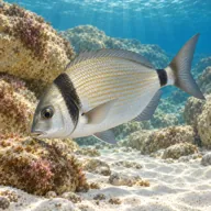
Two-banded sea bream
Almost always · Sargu
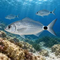
Saddled bream
Almost always · Kaħlija
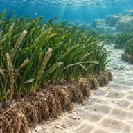
Posidonia meadow
Almost always · Alka

Common octopus
Often · Qarnit

Mediterranean moray
Often · Morina

Scorpionfish
Often · Ċippullazza

Dusky grouper
Sometimes · Ċerna
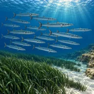
Barracuda
Sometimes · Lizz · late summer and autumn

Amberjack
Sometimes · Aċċola · autumn
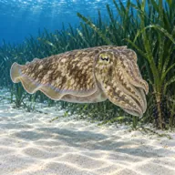
Cuttlefish
Sometimes · Siċċ · spring
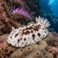
Nudibranchs
Sometimes · spring
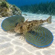
Flying gurnard
Lucky day · Bies
Getting in and staying safe
Boat is the sensible answer: fifteen to twenty minutes from Ċirkewwa or Mellieħa Bay, live drop onto the ridge and a pick-up wherever you surface. If you insist on shore, park on the open ground near the White Tower, walk the hundred and fifty metres of rough limestone to the northern shelf and expect a long swim out on the surface before you drop. Bring a delayed surface marker buoy either way, because the boat traffic across the Comino channel is constant in summer.
- Long surface swim and real risk of overexertion if diving from shore
- Heavy boat and ferry traffic in the Comino channel, so surface with a marker
- Current can run across the reef when wind and tide line up
- Depth creep, the sand edge is deeper than it looks from above
- Exposed position with nothing to hide behind if the wind picks up mid dive
- Uneven walk over limestone with kit, if entering from shore
A bit of history
No wrecks and no legends here, just geology. The reef is the drowned continuation of the Aħrax headland, Upper Coralline limestone fractured along the same faults that shaped the cliffs above water, which is why the canyons run in such a consistent direction. The whole northern tip sits inside an area of coastline that stayed in military hands well into the twentieth century and has never been built on.
Divers say
Sign in to rate this site and leave a note for the next diver.
- No reviews yet. First one gets bragging rights.
Further reading: Divers Guide, Ahrax Point site information · Dive Systems Malta, Ahrax Point · Divebooker, Ahrax Point · PADI dive site directory, L'Ahrax Point