Lantern Point · Comino
Lantern Point
Comino's signature dive: a vertical chimney in the limestone plateau that swallows you at 6 m and spits you out at around 17 m into a boulder cathedral, with a wall behind it that keeps falling to 50 m and beyond.
Sea conditions
Excellent right now
Some chop (0.4 m SSW)
Diveable for the rest of the day.
Forecast for the site, updated 12:44 PM · Models differ a little
Measured at Mġarr, Gozo (2.7 km away, 01:50 PM): 4 km/h from SSE, gusts 5. The next hours lean on it.
- Waves
- 0.4 m
- from SSW, biggest 0.7
- Wind
- 7 km/h
- N, gusts 13
- Swell
- 0.4 m
- 4 s period
- Sea temp
- 28 °C
- air 25 °C
Hour by hour
Next 7 days
Sunrise 06:48, sunset 19:04
Waves: Copernicus Med-Waves 4 km + MFWAM 8 km + EWAM 5 km + ECMWF WAM 9 km. Wind: ICON-2I 2 km + ECMWF IFS 9 km + ICON-EU 7 km + UKMO 10 km + ARPEGE 11 km. Read a few km out on the side the site is open to, then blended.
Exposed to wind and swell from: NW (315°), W (270°), SW (225°), S (180°). Needs near-perfect weather. Anything with west in it, and any leftover northwest swell rolling down the Comino channel, will close it. Sheltered from easterlies and from the southeast. Visibility is usually 25 to 40 m when it is diveable. Current is normally light but can pick up sharply right on the tip. Best season: June to October for reliable flat spells; September and October give the best combination of warm water and clarity..
Dives at Lantern Point
The dive
This is the dive people book the boat for. The southwest tip of Comino ends in a flat limestone shelf sitting at about six metres, and somewhere on that shelf is a hole. You hover over it, look down into the dark, and go. The shaft narrows, bends, and runs as a wide tunnel at the bottom before opening out into daylight at roughly seventeen metres. Coming out of it into a sunlit boulder garden is one of those thirty-second sequences that ends up in everybody's logbook in capital letters.
Beyond the chimney exit the terrain is enormous fallen blocks stacked into caverns and swim-throughs, and behind them the reef simply stops and becomes a wall. It falls past forty, past fifty, and keeps going into water that is a very serious blue. You do not have to go there. The shallower boulders between 15 and 25 metres are arguably the better dive, and they let you spend the whole tank in the interesting bit.
The catch is weather. The point sticks out into the channel and catches everything from the western half of the compass, so plans get rearranged here more than almost anywhere else in Malta. When it is on, it is on: flat water, 30 m of visibility, barracuda hanging off the corner, and the light coming down through the tunnel like something staged.
- Dropping into the chimney at 6 m and popping out at 17 m
- Boulder caverns and swim-throughs the size of rooms
- A wall that runs past 50 m for anyone carrying the training for it
- Barracuda and amberjack patrolling the corner in late summer
- Some of the clearest water in the archipelago when it is flat
Typical plan
Drop over the plateau at 6 m, torch on, and take the chimney down through the bend to the tunnel, exiting around 17 m. Work out over the boulders to the lip of the wall, drop to 30 to 35 m for a short look into the blue, then step back up in stages through the swim-throughs. Spend the back half between 12 and 18 m among the blocks, which is where most of the life is, and finish with a long stop on the plateau. Forty to fifty minutes on a 15 litre cylinder; 32 percent nitrox is ideal if you cap the deep leg at 30 m, air if you intend to go deeper. Torch, SMB and reel are not optional.
What the bottom looks like
- 1Chimney mouth in the limestone plateau6 m deep · 8 m out
- 2Wide tunnel at the base of the shaft15 m deep · 13 m out
- 3Sunlit tunnel exit onto the reef17 m deep · 16 m out
- 4Stacked blocks with caverns and swim-throughs24 m deep · 40 m out
- 5Lip of the main wall34 m deep · 75 m out
- 6Wall face continuing past 50 m45 m deep · 105 m out
- 7Shallow plateau for the safety stop14 m deep · 195 m out
Bare Coralline limestone plateau and wall, broken into huge collapse boulders with only thin rubble and sand between them.
Who you might meet
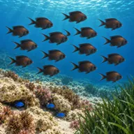
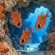
Often
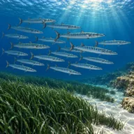

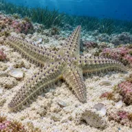
Sometimes
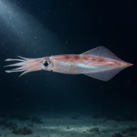

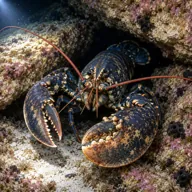
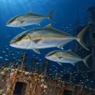
Marked ones can hurt you. What they do and what to do about it is under Getting in and staying safe.
Getting in and staying safe
Boat only, typically twenty to forty minutes out of Cirkewwa, Mgarr or Bugibba. There is no mooring buoy, so the drop is over the chimney with the boat standing off, and pick-up is wherever your SMB comes up. Nothing on shore: the nearest facilities are back at the harbour. Bring a torch even in bright sunshine, because the tunnel section genuinely goes dark.
- Overhead environment in the chimney and tunnel, with no direct ascent for part of it
- Surge amplifies inside the shaft and can bounce you off the walls
- Wall drops well beyond sport limits, so depth discipline matters
- Current sweeps around the point and can reverse
- Very exposed: conditions deteriorate fast once the wind swings west
- Busy summer boat traffic overhead, deploy an SMB before surfacing
- Silt and loose rubble in the tunnel if a group kicks it up
Marine life to respect
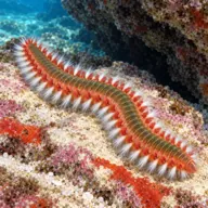
Bearded fireworm · Busuf Can hurt you
Bristles snap off in the skin and burn for hours. Never touch; lift them out with tape, then hot water.

Mediterranean moray · Morina Can hurt you
Bites hard if a hand goes into its hole. Keep hands out of cracks and never feed one.

Red scorpionfish · Ċippullazza Can hurt you
Venomous spines, and it sits still on the rock. Look before you kneel or hold on; hot water if stung.
A bit of history
The site takes its name from the lighthouse on the headland above, and the Maltese name Ras l-Irqieqa refers to the narrow point itself. The rock is Upper Coralline limestone, the hard cap layer of the Maltese sequence, which is why it forms clean vertical faces and why the chimney and the tunnels exist at all: they are solution features and fracture lines widened by sea water over a very long time, then enlarged by collapse. Local clubs split the area into two named dives, Lighthouse Reef on the south side of the light and Inner Lantern Point just north of it.
Divers say
Sign in to rate this site and leave a note for the next diver.
- No reviews yet. First one gets bragging rights.
Further reading: MaltaDives: Lantern Point (Ras l-Irqieqa) · Divers Guide: Lantern Point · Calypso Sub-Aqua Club: Lighthouse Reef · Calypso Sub-Aqua Club: Inner Lantern Point · Dive Shack Malta: Lantern Point