P31
A 52 m ex-East German minesweeper sitting upright on white sand off Comino's west coast, deck at 12 m and keel at 20 m. Easily the friendliest wreck in the islands, and shallow enough that snorkellers can see the whole thing.
 Wreck
Sea conditions
Stay dry right now
Sea is up (3.6 m WNW) · Fresh WNW wind (35 km/h) · Gusts to 59 km/h
Done for today. Tomorrow: not looking good. Best it gets is 22 at 16:00: Sea is up (1.4 m WNW)
Forecast for the site, updated 19:45 · Models disagree
Measured at Mġarr, Gozo (2.7 km away, 19:45): 31 km/h from WNW, gusts 37. The next hours lean on it.
- Waves
- 3.6 m
- from WNW, biggest 5.5
- Wind
- 35 km/h
- WNW, gusts 59
- Swell
- 0.4 m
- 7 s period
- Sea temp
- 22 °C
- air 19 °C
Hour by hour
Next 7 days
 0 3.6 m
45 W
 0 3.5 m
43 WNW
54 0.9 m14 W
 92 0.3 m
13 ESE
 90 0.3 m
12 E
90 0.3 m18 NNW
92 0.3 m16 SSW
Sunrise 06:26, sunset 17:06
Waves: Copernicus Med-Waves 4 km + MFWAM 8 km + EWAM 5 km + ECMWF WAM 9 km. Wind: ICON-2I 2 km + ECMWF IFS 9 km + ICON-EU 7 km + UKMO 10 km + ARPEGE 11 km. Read a few km out on the side the site is open to, then blended.
Exposed to wind and swell from: W (270°), NW (315°), SW (225°). Tucked on the west side of Comino, so it is sheltered from anything easterly and comfortable in a light northerly. A west or southwest blow puts chop straight onto it and makes the boat work unpleasant. Current is usually negligible. Visibility is commonly 20 to 30 m over the white sand, and the sand throws light back up so the wreck stays bright even on a dull day. Best season: April to November. Mid-summer brings the crowds and the tour boats; late September and October give warm water, better light and far fewer people..
The dive
P31 is the wreck you take someone on when you want them to fall in love with wreck diving. She sits bolt upright on a bright sand plain, the water over her is usually gin-clear, and the shallowest metalwork is barely seven metres down, so you get the full ship-shaped silhouette from the moment you hit the water. No decompression, no gloom, no anxiety. Just a whole boat, laid out for you.
Because she was prepared properly before scuttling, with doors, windows and both engines taken out and the mast removed, the interior is bright and open rather than a trap. Divers routinely run the length of her from stern to bow inside the hull, though the engine room has taken a lot of sand over the years and a careless fin kick will turn it into a snowstorm for everyone behind you. If you would rather not go in, there is no need: the deck fittings, the open wheelhouse and the sand around the hull carry plenty of interest on their own.
One quirk worth knowing: she shifted during the storms of the winter of 2010 and 2011 and now lies a little way off the buoy position, towards Cominotto, with the stern noticeably dug into the sand. Marine life on the hull is still building and is honestly a bit thin compared with Malta's older wrecks, so come for the structure and the light rather than for fish counts.
- A whole 52 m warship upright in 20 m of water
- Bright enough to photograph without strobes on a sunny day
- Straightforward stern-to-bow swim-through for trained divers
- Genuine no-decompression wreck diving for newly qualified divers
- Visible in outline from the surface, so snorkellers get something too
Typical plan
Descend the shot or swim down over the superstructure, drop to the sand at the bow for a look back along the hull (the classic photo), then work the deck aft at 14 to 16 m. If you are trained and the group is small, run the interior from stern to bow with good trim and a torch, otherwise stay outside and explore the sand around the hull. Come up over the bridge and finish on the shallow structure at 7 to 10 m. Fifty minutes is comfortable on a 12 litre cylinder at these depths, and 32 percent nitrox turns it into a very relaxed dive with no deco worries. Torch, SMB, and a hard rule about not kicking up the engine room.
What the bottom looks like
- 1Shallowest superstructure7 m deep · under the boat
- 2Bridge and open wheelhouse12 m deep · 8 m from the boat
- 3Foredeck and bow19 m deep · 29 m from the boat
- 4White sand under the bow20 m deep · 49 m from the boat
- 5Stern, dug into the sand18 m deep · 99 m from the boat
- 6Edge of the protected Posidonia meadow17 m deep · 134 m from the boat


Flat white sand, bright enough to act as a reflector, with Posidonia meadow beginning a short swim inshore of the hull.
Who you might meet
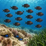
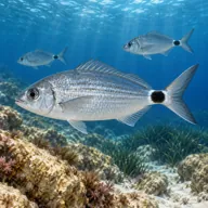
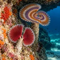
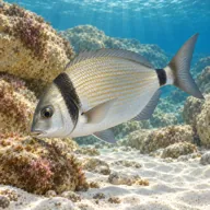
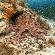

Sometimes
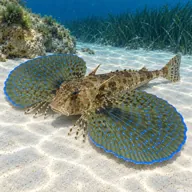

Lucky day
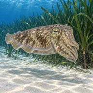
Marked ones can hurt you. What they do and what to do about it is under Getting in and staying safe.
Getting in and staying safe
Boat only. Dive centres run out from Ċirkewwa, Mġarr and the north of Malta, and the crossing is short. There is a buoy, though the wreck now lies roughly 25 m from it in the direction of Cominotto, so listen to the briefing about where to swim once you are down. Surface conditions in the bay are usually calm and the site is a standard stop on a two-tank Comino boat day, often paired with Santa Marija Caves. No facilities ashore, so everything comes off the boat.
Where the boat stops
Yellow marker buoy laid over the wreck
36° 0.540' N 14° 19.387' E
36.00900, 14.32312 · Open in Google Maps
Laid from May to October (Notice to Mariners 48 of 2017).
Positions as charted (WGS84) in Transport Malta Notice to Mariners 42 of 2017, special mark buoys indicating a wreck . Check the latest notice before you rely on them.
- Penetration: sand inside the engine room silts out instantly
- Very heavy summer boat traffic in the Blue Lagoon area overhead
- Sharp edges and cut-away openings in the hull
- Snagged fishing line and the occasional lost lead
- Easy to over-run the plan because the wreck is so inviting
- Open to the westerly quarter with no shelter if it builds
- Jellyfish drifting through in late summer
Marine life to respect

Common stingray · Boll Can hurt you
Whips a barbed tail if stepped on or cornered. Stay off the sand and give it room.
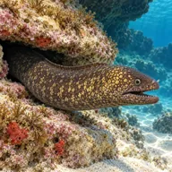
Mediterranean moray · Morina Can hurt you
Bites hard if a hand goes into its hole. Keep hands out of cracks and never feed one.
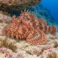
Red scorpionfish · Ċippullazza Can hurt you
Venomous spines, and it sits still on the rock. Look before you kneel or hold on; hot water if stung.
A bit of history
She began life as Pasewalk, pennant GS05, a Kondor I class minesweeper laid down at the Peenewerft yard in Wolgast on 12 December 1968, launched on 18 June 1969 and commissioned that October for East Germany's Volksmarine. Roughly 52 m long with a 7.1 m beam and about 361 tonnes displacement, she swept mines and patrolled the river border between the two Germanys until the Volksmarine was wound up in 1990. Malta bought her, disarmed, in July 1992 alongside sister ship Ueckermünde (which became P30); a third sister, Boltenhagen, followed in 1997 as P29. All three served the Maritime Squadron of the Armed Forces of Malta on anti-smuggling and border work, and all three were decommissioned in 2004. The Malta Tourism Authority acquired P31 and scuttled her off Comino in late August 2009 (sources give 24 and 25 August) as an artificial reef, after stripping the hazards, pulling the engines and shifting the drop point by about thirty metres to spare a Posidonia meadow. Her sister P29 had already gone down in deeper water off Ċirkewwa in 2007.
Divers say
Sign in to rate this site and leave a note for the next diver.
- No reviews yet. First one gets bragging rights.
Further reading: Wikipedia: Maltese patrol boat P31 · MaltaDives: P31 wreck · Wrecksite: P31 (ex-Pasewalk) · PADI dive site: Comino Island P31 Patrol Boat · DiveWise Malta: The P31 patrol boat wreck