Marsaskala · Malta
Żonqor Point
The low limestone headland guarding the north side of Marsaskala Bay, with easy shore-diveable reef on both flanks and a maximum depth of about twenty metres.
Sea conditions
Good right now
Some chop (0.5 m E)
Forecast for the site, updated 01:46 AM
- Waves
- 0.5 m
- from E
- Wind
- n/a
- Swell
- 0.5 m
- 5 s period
- Sea temp
- 29 °C
Next 7 days
Exposed to wind and swell from: NE (45°), E (90°), SE (135°), S (180°). The classic Maltese north west refuge. Wind from the north west leaves this corner flat. East or south east puts swell onto both entries and stirs the shallows into soup. Best season: All year. May to November for the warmest, clearest water, and any month at all when the north coast is blown out..
The dive
Żonqor is Malta's most reliable easy day out. A flat, low headland with parking almost at the water, rock entries on either side, and a reef that never gets deep enough to worry anyone. It is where half the island's training happens and where everyone ends up when the north westerly shuts down Ċirkewwa and Dwejra.
The southern flank is the busy one, because it is the route home from the tugboat wrecks. That reef slopes down gently, rock and low ledge covered in a surprisingly bright carpet of encrusting growth, and it holds fish in numbers because the wrecks next door act as a nursery. Most divers finish their tank here, drifting along at five to ten metres and counting octopus.
The northern side, signposted in guides as Żonqor Point North, has its own entry and exit points a few hundred metres further along and is the quieter dive. Close to shore there are big boulders with real gullies between them, deep enough to swim along with walls on both sides. Further out the boulders shrink, the gullies fade, and the bottom slides away slowly towards twenty metres and sand.
Neither side is spectacular. Both are pleasant, forgiving and genuinely fun, and the combination of shallow water, easy access and a cafe within a hundred metres of your fins makes this one of the best second dives on the island.
- Reef on both sides of the headland with parking at the water
- Boulder gullies on the north flank that you can swim along
- The natural shallow finish to a tugboat wreck dive
- Shallow enough for very long, very relaxed dives
- Cafes, toilets and a dive centre within a short walk
Typical plan
For the south side, enter off the rocks, follow the reef out to twelve or fifteen metres, turn when you reach half your gas and return along the shallower ledges at five to eight metres. For the north side, enter at the separate access points, drop into the boulder gullies at six to nine metres and work outwards until the ground flattens at around eighteen, then reverse. Either version runs fifty to sixty minutes on a single 12 litre of air with plenty in reserve. No decompression concerns, so this is the place to practise buoyancy, navigation and photography.
What the bottom looks like
- 1Large boulders and swimmable gullies near shore6 m deep · 30 m out
- 2Sloping reef with ledges and overhangs12 m deep · 90 m out
- 3Patchy Posidonia on the north side13 m deep · 120 m out
- 4Reef edge before the sand17 m deep · 175 m out
- 5Sand plain, where the tug wrecks lie to the south20 m deep · 250 m out
Rock, ledge and boulder close in, giving way to sand and patchy seagrass past about eighteen metres.
Who you might meet
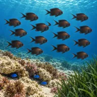
Damselfish
Almost always · Pixxi kahal · Summer
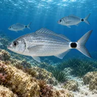
Saddled seabream
Almost always · Kaħlija
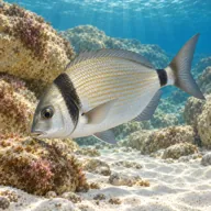
Common two-banded seabream
Almost always · Sargu
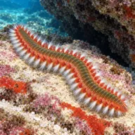
Fireworms
Almost always · Busuf · Summer
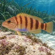
Painted comber
Almost always · Burqax

Octopus
Often · Qarnit · Autumn and winter

Mediterranean moray
Often · Morina
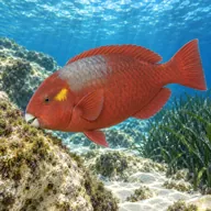
Mediterranean parrotfish
Often · Marnott · Summer

Scorpionfish
Often · Skorfna
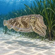
Cuttlefish
Sometimes · Siċċa · Spring
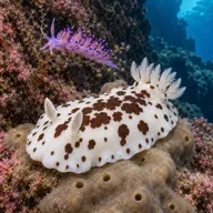
Nudibranchs
Sometimes · Spring
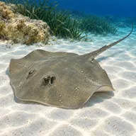
Common stingray
Lucky day · Boll
Getting in and staying safe
As easy as Maltese shore diving gets. Drive to the point, park on the open ground, and kit up next to the car. Public toilets, kiosks, cafes and restaurants are right there, several of them seasonal, along with a dive centre and the large outdoor pool complex that everyone uses as a landmark. Entry on the south side is over low rocks a short walk from the parking; the north side has its own entries about three hundred metres further along. Rocks are slippery and urchin-covered, so choose an exit that will still work if a little swell arrives while you are down.
- Slippery rock entries and dense sea urchins
- Boat traffic in and out of Marsaskala Bay
- Visibility poorer than the rest of Malta, especially after rain
- Discarded fishing line and hooks near the point
- Surge in the gullies on the north side when there is any easterly swell
- Busy site in summer, with swimmers and snorkellers overhead
- Jellyfish in late summer
A bit of history
Żonqor Point is a low platform of Maltese limestone on the northern arm of Marsaskala Bay. It was chosen in 1998 as the site for the scuttling of the tugs St. Michael and Number 10 precisely because of its combination of shelter from the prevailing north west winds, bare sand free of protected Posidonia meadow, and a depth reachable by ordinary recreational divers. The patrol boat P33 joined them in 2021. Above water the headland has been at the centre of Malta's development debates for years, which is why the open ground behind it stays open.
Divers say
Sign in to rate this site and leave a note for the next diver.
- No reviews yet. First one gets bragging rights.
Further reading: Malta Dive Sites: Żonqor Point · Malta Tourism Authority Dive Site Report 5: Zonqor Point North · Malta Dive Sites: Marsaskala area overview