Xatt l-Ahmar · Gozo
Xatt l-Ahmar Reef
The wall and boulder run along the southern edge of Red Bay, with caves and overhangs at the top and a drop-off falling to thirty. A proper dive in its own right, not just the road to the wrecks.
Sea conditions
Excellent right now
Flat, sheltered and calm
Forecast for the site, updated 01:45 AM
- Waves
- 0.3 m
- from SE
- Wind
- n/a
- Swell
- 0.2 m
- 5 s period
- Sea temp
- 29 °C
Next 7 days
Exposed to wind and swell from: E (90°), SE (135°), S (180°), SW (225°). One of the very few Gozo sites that actually works when the north-westerly is howling, which is why boats and centres head here on bad days. Easterly through southerly winds put swell into the bay and rule it out. Little or no current, and visibility is usually generous. Best season: April to November, and a dependable winter choice in north-westerly weather.
The dive
Everything at Xatt l-Ahmar happens on this reef, and most divers only meet it at speed. Pick a day when you are not going deep, take a torch, and dive it properly instead.
Swim out of the bay and the plateau at five to nine metres runs to a rim and then tips over. The drop-off tracks south-west, and instead of a clean wall you get a jumble of boulders, some the size of a car and some the size of a van, stacked into overhangs, cracks and small caves. Grouper sit under them, moray occupy the gaps, and there are enough dark holes to keep a torch pointed somewhere useful for the whole dive. Between the rock are fields of Posidonia and pale sand.
The reef bottoms out around thirty metres on the boulder slope, which is comfortable for an experienced recreational dive and a nice change from the deco discipline the wrecks demand. From the lip, on a good day, you can look down the sand slope and pick out the wrecks lying on it, which is the sort of view that ruins your gas plan if you are not careful.
The return is the best part: come back up onto the shelf at seven or eight metres and finish in the shallows, where sardines and sprat shoal in thousands in summer and the light is much kinder. Keep an eye on sand patches on the way for rays.
- Boulder architecture with caves, cracks and overhangs to torch through
- Resident grouper and moray at a sane twenty to thirty metres
- The drop-off view down the sand slope towards the wrecks
- Works on days when north-westerly wind closes the rest of Gozo
- Huge baitfish shoals on the shallow shelf in summer
Typical plan
In off the ladders, cross the shelf south-west at seven or eight metres to the rim, then drop over and work the boulder stacks along the drop-off at twenty to twenty-five, poking into the overhangs with a torch. If you want the bottom of the slope, take a few minutes at thirty and turn there. Come back on a reciprocal bearing up onto the shelf and spend the last twenty minutes at six to nine metres in the baitfish. Fifty to sixty minutes on a single twelve, air is fine, nitrox 32 buys you a longer look at the boulders.
What the bottom looks like
- 1Outer edge of the shallow shelf9 m deep · 120 m out
- 2Lip of the drop-off running south-west14 m deep · 165 m out
- 3Large boulder stacks and overhangs20 m deep · 200 m out
- 4Small caves and cracks under the boulders22 m deep · 225 m out
- 5Posidonia and sand between the rock27 m deep · 260 m out
- 6Base of the boulder slope at thirty metres30 m deep · 285 m out
Fractured coralline limestone boulders and slabs with Posidonia meadows and sand channels running between them.
Who you might meet
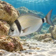
Two-banded seabream
Almost always · Sargu

Damselfish and goldies over the boulders
Almost always · Chromis chromis

Cardinalfish in the overhangs
Almost always · Apogon imberbis
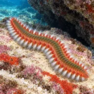
Fireworm
Almost always · Hermodice carunculata

Dusky grouper
Often · Ċerna

Moray eel
Often · Morina

Octopus
Often · Qarnita
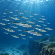
Sardine and sprat shoals in the shallows
Often · Sardin · Summer

Scorpionfish
Often · Ċippullazza
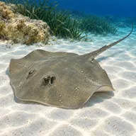
Common stingray on sand patches
Sometimes · Dasyatis pastinaca
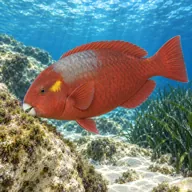
Mediterranean parrotfish
Sometimes · Marzpan
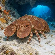
Slipper lobster
Lucky day · Scyllarides latus
Getting in and staying safe
Same approach as the rest of Red Bay: rough narrow lane down from Ghajnsielem below Mgarr, park and kit at the bottom, short walk to the rocky shore and in off the seasonal steel ladders. From the ladders the reef edge is a few minutes of easy swimming south-west, either on the surface or, more comfortably, under it. Boat dives are perfectly possible and let you start straight on the drop-off. No facilities on site at all, so plan to eat and change elsewhere.
- Depth creep, because the slope keeps going and the wrecks are visible from it
- Overhangs and small caves that are dark and easy to silt out
- Sharp rock and sea urchins around the entry and shallows
- Slippery rocks and seasonal ladders at the exit
- Fishing line snagged on the reef edge
- Boat traffic from Mgarr and the dive boats working the wrecks
- Long walk back up to the car in kit
A bit of history
The reef is the seaward edge of the Xatt l-Ahmar platform on Gozo's south-east coast, coralline limestone that has fractured and slid down the slope over a very long time, which is why it reads as boulder chaos rather than a clean wall. Since 1999 it has acquired a second job as the approach route and decompression ground for the four wrecks scuttled on the sand below it, starting with the MV Xlendi and most recently the tanker Hephaestus in 2022.
Divers say
Sign in to rate this site and leave a note for the next diver.
- No reviews yet. First one gets bragging rights.
Further reading: Calypso Sub Aqua Club: Xatt l-Ahmar · Malta Dives: Xatt l-Ahmar Reef · Atlantis Gozo: Xatt l-Ahmar