Xatt l-Ahmar · Gozo
Xatt l-Ahmar Bay
The shallow half of Red Bay: a gentle rock and seagrass plateau just inside the ladders, ideal for training, check dives, a lazy second dive or a night dive while everyone else decompresses.
Sea conditions
Excellent right now
Flat, sheltered and calm
Forecast for the site, updated 01:45 AM
- Waves
- 0.3 m
- from SE
- Wind
- n/a
- Swell
- 0.2 m
- 5 s period
- Sea temp
- 29 °C
Next 7 days
Exposed to wind and swell from: E (90°), SE (135°), S (180°), SW (225°). Very well sheltered from the north-westerly, which makes Red Bay the standard answer when the rest of Gozo is out of action. Easterly and southerly winds send swell right into the bay and the rocky entry becomes the deciding factor long before the visibility does. Essentially no current inside the bay. Best season: May to October for warm water and the ladders in place, and a reliable winter option whenever the wind is north-westerly.
The dive
Most people who come to Xatt l-Ahmar swim straight over this bit on their way to a forty-metre wreck, which is a small tragedy. The bay itself is a pleasant, forgiving dive: a reddish rocky shoreline, a plateau at four to nine metres of slab, boulder and Posidonia, and enough small life to keep a camera busy for an hour.
Stay inside the bay and you have a perfect training site. It is shallow, there is no current to speak of, the bottom is varied enough to make navigation exercises real, and there is a natural boundary at the drop-off to keep a class from wandering. Instructors use it constantly, and it is the obvious place to do a check dive on the first morning of a Gozo trip.
Drift towards the southern edge and the ground starts to tip. Follow it and you will be at twelve, then twenty, then on the lip of the drop-off that runs down to thirty and eventually to the wrecks. That gives the bay a nice property: you can make it as easy or as serious as your qualification allows without changing sites.
It also earns its keep as a decompression garden. If you have just come back up from the Karwela, the last twenty minutes of your dive happen here, and there are sardine and sprat shoals, wrasse, small grouper under the slabs and the odd ray parked on a sand patch to make that time pass properly.
- Genuinely easy shallow diving in the most sheltered corner of Gozo
- Ideal for training, check dives and photography in four to twelve metres
- Sand pockets that regularly hold a resting ray
- A tidy night dive, with the car park right above you
- The perfect decompression and surface-interval site when the group is doing the wrecks
Typical plan
In off the ladders, potter west and south across the plateau at five to nine metres, working the boulder edges and the seagrass margins where the small stuff lives, then turn along the southern edge to where the ground tips towards twelve or fifteen. Come back over the shallows into the bay for the last fifteen minutes. Sixty minutes on a single twelve on air is entirely normal and you will still surface with gas. As a night dive it is even better, with octopus and cuttlefish out on the slabs.
What the bottom looks like
- 1Shore boulders below the ladders4 m deep · 25 m out
- 2Posidonia patches on the plateau7 m deep · 80 m out
- 3Sand pockets between slabs, ray territory9 m deep · 140 m out
- 4Southern edge where the plateau starts to tip16 m deep · 210 m out
- 5Lip of the drop-off towards the wrecks22 m deep · 250 m out
- 6Large boulders on the upper slope30 m deep · 320 m out
Flat coralline limestone slab and boulder with Posidonia beds and clean sand pockets between them.
Who you might meet
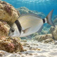
Two-banded seabream
Almost always · Sargu
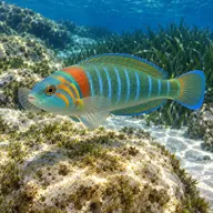
Ornate wrasse
Almost always · Thalassoma pavo
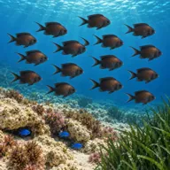
Damselfish
Almost always · Chromis chromis
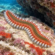
Fireworm
Almost always · Hermodice carunculata
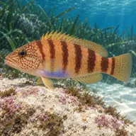
Painted comber
Almost always · Serranus scriba

Octopus
Often · Qarnita
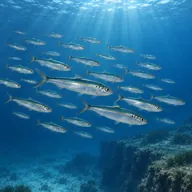
Sardine and sprat shoals
Often · Sardin · Summer

Scorpionfish
Often · Ċippullazza

Small dusky grouper under the slabs
Sometimes · Ċerna
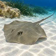
Common stingray on sand patches
Sometimes · Dasyatis pastinaca
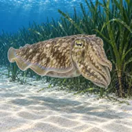
Cuttlefish
Sometimes · Siċċa · Spring
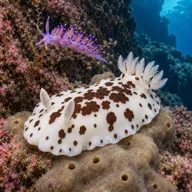
Nudibranchs in the seagrass
Sometimes · Spring
Getting in and staying safe
A narrow, winding and rough lane runs down from Ghajnsielem, below Mgarr, to a parking and kitting area that has been improved in recent years. Higher ground clearance helps and a four-wheel drive is genuinely useful after rain. From the parking it is a short walk down to the rocky shore, where two steel ladders are fitted for the diving season and taken out over winter. Entry and exit are on rock, so reef boots or fins on at the ladder. No toilets, no cafe, no shade and no fresh water at the site, so the nearest facilities are in Mgarr or Ghajnsielem, a few minutes back up the hill.
- Slippery rock at the ladders, especially with any swell running
- Ladders are removed in winter, which turns the exit into a scramble
- Rough access track and a walk back up to the car in kit
- Sea urchins on the shallow rock
- Depth creep if you follow the slope out past the drop-off
- Boat traffic from Mgarr and dive boats working the wrecks
- Jellyfish drifting in during late summer
A bit of history
The name means the red shore, for the ochre-coloured rock and the reddish soil washing down the valley behind it. The bay sits just west of Mgarr harbour on Gozo's south-east coast, ground that saw plenty of small-boat traffic between Malta and Gozo long before the ferry ran. Its modern fame is entirely borrowed: the Gozo Tourism Association chose the slope outside it for the island's artificial reef programme, sinking the Xlendi here in 1999, the Karwela and Cominoland in 2006 and the tanker Hephaestus in 2022.
Divers say
Sign in to rate this site and leave a note for the next diver.
- No reviews yet. First one gets bragging rights.
Further reading: Calypso Sub Aqua Club: Xatt l-Ahmar · Malta Dives: Xatt l-Ahmar Bay · Atlantis Gozo: Xatt l-Ahmar