Wied iz-Zurrieq · Malta
Wied iż-Żurrieq
A slot of a fishing harbour on Malta's south coast that happens to be the best-value shore diving address on the island: two reefs, two caves, a statue and the country's signature wreck, all from one set of ladders.
Sea conditions
Good right now
Some chop (0.5 m S)
Diveable for the rest of the day. Lowest point 65 around 17:00.
Forecast for the site, updated 12:44 PM · Models differ a little
Measured at Delimara (12.3 km away, 01:50 PM): 4 km/h from NW, gusts 5. The next hours lean on it.
- Waves
- 0.5 m
- from S, biggest 0.8
- Wind
- 5 km/h
- WSW, gusts 12
- Swell
- 0.4 m
- 4 s period
- Sea temp
- 29 °C
- air 25 °C
Hour by hour
Next 7 days
Sunrise 06:47, sunset 19:03
Waves: Copernicus Med-Waves 4 km + MFWAM 8 km + EWAM 5 km + ECMWF WAM 9 km. Wind: ICON-2I 2 km + ECMWF IFS 9 km + ICON-EU 7 km + UKMO 10 km + ARPEGE 11 km. Read a few km out on the side the site is open to, then blended.
Exposed to wind and swell from: S (180°), SW (225°), SE (135°), W (270°), NW (315°). The inlet itself is well sheltered and often diveable when the outer sites are not, while the reefs and the wreck sit in the open and take southerly swell head on. A strong northwesterly wraps round the island and reaches this coast too, which is when the Blue Grotto boats stop running. A useful rule: if the luzzus are not going out, stay inside the valley or go somewhere else. Best season: April to November for the full menu. Water around 15 to 16 C at the winter low and up to 26 C in late summer. Autumn often gives the clearest water, and the valley works year round..
Dives at Wied iż-Żurrieq
Um El Faroud
Wied iz-Zurrieq, Malta
West Reef & Caves
Wied iz-Zurrieq, Malta
East Reef
Wied iz-Zurrieq, Malta
Valley
Wied iz-Zurrieq, Malta
Blue Grotto Caves
Wied iz-Zurrieq, Malta
The dive
Wied iż-Żurrieq is a village in name only, a road that runs downhill and stops at a narrow inlet full of painted luzzu boats. Tourists come for the Blue Grotto trip. Divers come because you can park, walk down a ramp, climb down a ladder and reach four completely different dives without a boat.
Turn left and East Reef runs east as a broad ledge that tips into a wall dropping past 30 metres, with big shoals and unusually good visibility. Turn right and West Reef gives you ledges, gullies, drop-offs and two caves, Bell Tower with its three stacked entrances and the tight-mouthed Mouse Hole. Carry on past a brass diving helmet statue sitting on sand at 28 metres and you arrive at the Um El Faroud, 110 metres of Libyan tanker lying upright and broken in two. And the inlet itself is a fine shallow dive and one of the best night dives in the south.
The practical stuff is well sorted. Parking is informal at the bottom of the hill and official a little further back, there are four ladders and a slipway, and there are cafes and public toilets on the quay. In July and August the whole place is heaving and parking becomes a competitive sport, so an early start pays twice over.
One piece of naming pedantry worth knowing: this site is often sold as Blue Grotto diving, but the actual Blue Grotto is a kilometre east and is almost never dived. What you are diving is Żurrieq.
- Four genuinely different dives from one set of ladders
- Malta's best wreck, the Um El Faroud, reachable from shore
- Bell Tower and Mouse Hole caves on West Reef
- Brass diving helmet statue on the sand at 28 metres
- Cafes, toilets and parking a few metres from the water
Typical plan
Treat it as a two-tank day. Morning dive on the Um El Faroud while you are fresh and gas planning matters most: out past the helmet statue, work the wreck from stern to bow, back up over the funnel and home along the sand. Long surface interval with lunch on the quay. Afternoon dive on whichever reef suits the current, or the valley if the wind has got up. Nitrox 28 to 32 for the wreck, air is plenty for the reefs and the inlet. Carry a DSMB every time, and always plan your return to the inlet, since it is the only way out.
What the bottom looks like
- 1Quay ladders and slipway3 m deep · 30 m out
- 2Mouth of the inlet, reefs left and right13 m deep · 150 m out
- 3East Reef wall to the left18 m deep · 230 m out
- 4West Reef caves to the right27 m deep · 250 m out
- 5Brass diving helmet statue on sand28 m deep · 320 m out
- 6Um El Faroud beyond the sand30 m deep · 380 m out
Rock and rubble in the inlet, fissured limestone reef either side, and seagrass over sand out towards the wreck.
Who you might meet
Almost always

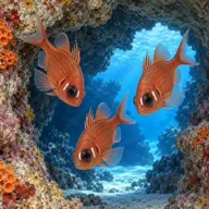

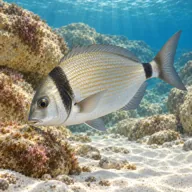
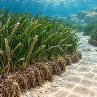
Often

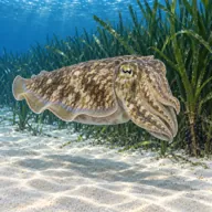

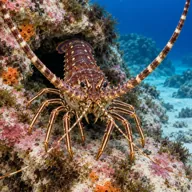
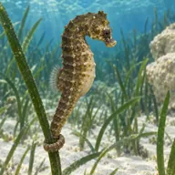
Marked ones can hurt you. What they do and what to do about it is under Getting in and staying safe.
Getting in and staying safe
Informal diver parking at the bottom of the hill where the road ends, close to the stairs down to the quay, or near the top of the ramp; street parking is also possible, and there are two official car parks 150 to 200 metres away. Summer is extremely busy and parking can be genuinely difficult. Down to the quay by stairs or ramp. Four ladders along the quay: one directly below the stairs, two roughly 20 metres either side of it, and one inside the bay next to the tourist boat embarkation point. The slipway extends the ramp into the water, and giant strides work from anywhere along the concrete. For East Reef there is an entry-only point along a path to the east; there is no exit there. The inlet is the only exit in the area, so plan every dive to come back to it, and in rough conditions the sheltered slipway may be the only option. Check the ladders are in place before you kit up, especially in winter. The concrete goes slippery with algae, particularly on the slipway. Restaurants, cafes, tourist shops and public toilets on the quay, long hours in summer and much shorter in winter. Entry and exit points get crowded at peak times.
- Busy tourist boat traffic to and from the Blue Grotto, DSMB strongly advised
- Strong currents can run even when the sea looks calm
- Slippery concrete quay and slipway
- Ladders removed or lost in winter storms, always check first
- Anglers on the shore, enter away from their lines
- The inlet is the only exit, so gas planning is not optional
- Deep sites, the wreck at 36 m and both reef walls past 30 m
- Crowded entry points in July and August
- Mauve stinger jellyfish in spring and autumn
Marine life to respect

Mediterranean moray · Morina Can hurt you
Bites hard if a hand goes into its hole. Keep hands out of cracks and never feed one.

Red scorpionfish · Ċippullazza Can hurt you
Venomous spines, and it sits still on the rock. Look before you kneel or hold on; hot water if stung.
A bit of history
The inlet has been a small fishing landing for centuries, and the luzzus moored here still carry the painted eye on the bow that Maltese boats inherited from Phoenician practice. The cliffs are Upper Coralline limestone sitting over softer beds, worked by the sea into the arch and caverns of the Blue Grotto to the east and the gullies and caves of the reefs below. Modern diving history has two dates: 3 July 2005, when ATLAM Sub Aqua Club placed the diving helmet statue on the sand for its fiftieth anniversary, and 2 September 1998, when the Um El Faroud was towed out of Grand Harbour and sunk offshore, turning a good reef site into a world-class one.
Divers say
Sign in to rate this site and leave a note for the next diver.
- No reviews yet. First one gets bragging rights.
Further reading: Malta Dive Sites: Wied iz-Zurrieq (Blue Grotto) · Malta Tourism Authority, Dive Site Report 8: East Reef, West Reef & Caves and Um el Faroud (PDF) · Dive Systems Malta: Zurrieq Reef and Caves · Wikipedia: Blue Grotto, Malta · SkylineWebcams: live view of Wied iz-Zurrieq