HMT Crownsin
A 137 ton requisitioned trawler, German built and taken as a prize in 1915, mined east of the Grand Harbour on 4 May 1916 with eleven of her crew. She was the fourth and last ship killed by the same U 73 minefield that took HMS Russell, and unlike the other three she has never been found.
 Wreck
Divers rarely, if ever, come here.
We found no record of anyone diving this site. It is charted so the picture of what lies under the water is complete, not because it is a place to go: there is no set route, no local briefing to lean on, and nothing on this page has been proven in the water.
Sea conditions
Reading the sea…
Exposed to wind and swell from: NW (315°), N (0°), NE (45°), E (90°), SE (135°), S (180°). Fully offshore. Malta blocks nothing except the western quarter, so the northwesterly majjistral and the northeasterly grigal both arrive with open fetch behind them, and easterlies come all the way from Crete. You need a genuinely flat day, not merely a diveable one, because everything here happens on a live boat with long decompression hanging in blue water. Current is usually gentle but is unbroken at this distance from land. Best season: Late May to early October. June and September tend to give the flattest surface, which matters far more here than water temperature does..
The dive
Three of the four ships that died in U 73's minefield are now signature technical dives with Heritage Malta tickets and guided lines. The fourth is this one, and she is still out there somewhere under the shipping lane, unphotographed and unvisited. That gap is the whole story of the site.
Crownsin started as the German steam trawler Varel, built at Geestemuende in 1895, 32.5 m of riveted steel with a triple expansion engine and a very ordinary working life ahead of her. The war reassigned her twice: captured by the cruiser Arethusa in October 1915, then hired into the Royal Navy as a patrol and sweeping trawler, which in the Malta of spring 1916 meant working exactly the water that had just swallowed a battleship. On 4 May she found a mine of her own. Eleven men died on a boat with a crew you could fit round two tables.
What that means for a diver is worth stating plainly. There is no confirmed position, no depth on any chart, no dive report and no photograph. The best reasoning available puts her in about 95 to 100 m of water on soft sediment, in the same band as the Russell at 110 m and a good deal deeper than the Aegusa and the Nasturtium at 70 odd. A hull that size, iron, mined, and 110 years down, will be broken and low.
Treat her as a search project rather than a dive. She is a war grave, she is well over the fifty year threshold that makes her protected under Malta's Cultural Heritage Act, and the minefield she lies in was never fully accounted for. Anything you do here starts with Heritage Malta and a sonar day, not with a boat and a stage bottle.
- The one ship from the 1916 Grand Harbour minefield that nobody has ever found
- A German trawler captured, renamed, and then killed flying the flag that took her
- Sits among three of Malta's best known deep wrecks, the Russell, the Aegusa and the Nasturtium
- A genuine blank on the chart within a short boat ride of Valletta
- Eleven names on the Chatham and Plymouth memorials and nothing on the seabed to mark them
Typical plan
There is no typical plan, because there is no dive yet. The honest sequence is a sonar day first, sweeping the box east of the Grand Harbour between the Aegusa and Nasturtium marks, then a permit conversation with Heritage Malta before anyone gets wet. If a target is confirmed at the depth the bathymetry suggests, assume roughly 95 to 100 m: hypoxic trimix bottom mix, twin stages, fifteen to twenty minutes on the wreck against well over an hour of decompression, a deployed line and a boat that stays live the whole time. Anyone planning it off a single marker on a map is planning the wrong thing.
What the bottom looks like
- 1Estimated remains of the trawler, never located or confirmed97 m deep · under the boat
- 2Soft sediment plain of the outer harbour shelf98 m deep · 46 m from the boat
- 3Open search box, no relief of any kind99 m deep · 136 m from the boat


Soft grey mud and shelly sand across the outer Grand Harbour shelf, flat and featureless apart from whatever iron is buried in it.
Who you might meet
Almost always
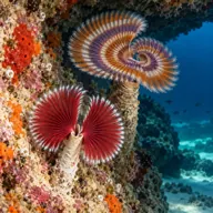
Sometimes
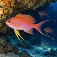
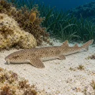
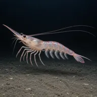
Lucky day
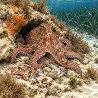
Marked ones can hurt you. What they do and what to do about it is under Getting in and staying safe.
Getting in and staying safe
Only for serious professionals who know exactly what they are doing. With no record of anyone diving here there is no one to ask and no set route, so treat every line below as the start of your own planning, not a briefing. Plan it as an expedition, not a dive.
Boat only, and there is no established trip to join. The nearest sensible departures are the Grand Harbour, Kalkara and Marsaskala, the same places the charters for the Russell, Aegusa and Nasturtium leave from, with a run of roughly 14 km out to the marker. There is no mooring, no buoy and nothing to shoot a line at until somebody finds her, so any visit means live boating over a search box. Historic wrecks in Maltese waters are accessed through Heritage Malta and registered dive centres, so the first phone call is to them and not to a skipper.
- Wreck has never been located, so any trip is an open water search rather than a dive
- Estimated depth around 95 to 100 m, which is hypoxic trimix, staged deco and a full support team
- Sits under the busy eastern approach to the Grand Harbour, with commercial traffic and no shotline to hide under
- Unswept ordnance is a documented concern across this minefield
- War grave with eleven men lost, and a protected site under Malta's Cultural Heritage Act
- Ghost nets and snagged fishing gear are a known problem on the neighbouring wrecks in this field
- No mooring means long open water deco with the boat live, and any current runs unbroken this far offshore
- Silty sediment bottom that will go to zero visibility the moment fins touch it
Marine life to respect
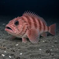
Blackbelly rosefish · Ċippullazza tal-għajn Can hurt you
Venomous spines, like a scorpionfish. Do not handle it; hot water if stung.
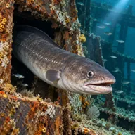
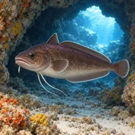
Conger eel · Gringu Can hurt you
Crushing bite if a hand goes into its hole. Look in from a distance and keep fingers out.
A bit of history
Built in 1895 by J. C. Tecklenborg at Geestemuende as the German fishing trawler Varel, registered PG 47. Steel hull of about 137 gross tons, 32.5 by 6.3 by 2.7 m, triple expansion engine, around 10.5 knots. Captured by the British light cruiser HMS Arethusa on 7 October 1915 and taken into Royal Navy service as the hired trawler Crownsin.
On 25 to 27 April 1916 the minelaying submarine U 73, under Gustav Siess, laid twenty two mines across the approaches to the Grand Harbour. The field sank the battleship HMS Russell on 27 April, the sloop HMS Nasturtium the same evening, and the armed yacht HMY Aegusa hours later while she was helping with survivors. A week after the field was laid, on 4 May 1916, Crownsin became its fourth victim. Eleven of her crew were lost and are commemorated on the Chatham and Plymouth Naval Memorials.
Given the date and her role, she was in all likelihood working on that same field when it killed her, though no source states it outright.
Divers say
Sign in to rate this site and leave a note for the next diver.
- No reviews yet. First one gets bragging rights.
Further reading: uboat.net, navy trawler Crownsin · Wrecksite, HMT Crownsin ex Varel · Wikipedia, SM U 73 and the Grand Harbour minefield · Heritage Malta, HMS Russell · Underwater Malta, HMS Nasturtium · MaltaDives, HMT Crownsin listing