Cominotto · Comino
Blue Lagoon
Malta's most photographed stretch of water, and one of its least dived: three metres of white sand under absurdly blue water, with boat propellers overhead all summer.
Sea conditions
Excellent right now
Flat, sheltered and calm
Forecast for the site, updated 01:45 AM
- Waves
- 0.3 m
- from SE
- Wind
- n/a
- Swell
- 0.2 m
- 5 s period
- Sea temp
- 29 °C
Next 7 days
Exposed to wind and swell from: N (0°), NW (315°). The lagoon is well sheltered, which is exactly why every boat in the country parks in it. Weather from the south and east barely registers. A strong northerly or north-westerly pushes swell down the channel and stirs the sand, and that is about the only thing that closes it. Best season: April to June and late September to November for the water without the crowds. In July and August dive before 08:00 or not at all..
The dive
The Blue Lagoon is a victim of its own postcard. The channel between Comino and Cominotto is a shallow sand-floored basin where the water turns that improbable turquoise, and in July it carries thousands of day-trippers and a permanent taxi rank of boats. As a dive it is mostly used for training, check-outs and first breaths, which is exactly what the sand at three metres is good for, and why serious logs rarely record it as a dive of its own.
That said, if you get there at first light before the fleet arrives, it is genuinely lovely. Visibility is regularly fifteen to twenty-five metres and can be better, the bottom is clean white sand with scattered limestone outcrops, and towards the deeper edges Posidonia meadows take over and the depth eases down to around twelve or fourteen metres. Octopus, seabream, moray and scorpionfish all live in the rock margins, and the seagrass is worth searching slowly.
Buoyancy is the whole point here. The sand is fine and stirs at the first careless fin kick, so a group that swims badly will be diving in their own dust within five minutes. As a training environment that is a feature rather than a bug: mistakes are immediately visible and immediately fixable.
Do not plan it as an afternoon dive in season. Between about nine in the morning and late afternoon the surface is a hazard rather than a backdrop.
- The most forgiving training bottom in the Maltese islands
- Light through three metres of water over white sand, which photographs like nothing else
- Posidonia meadows at the deeper edges worth a slow search
- Easiest site on Comino to reach without a dive boat
Typical plan
A shallow, gas-limited wander rather than a dive with a profile. Enter from the Comino shelf or off the boat, cross the sand at three to five metres, follow the rocky margin along the Cominotto side and drop to nine or twelve over the seagrass before turning back. Air is fine, nitrox is pointless, and an hour and a half in the water is achievable. Stay low, look up before ascending, and surface at the edge of the bay rather than in the middle of it.
What the bottom looks like
- 1White sand training flat3 m deep · 40 m out
- 2Scattered limestone outcrops5 m deep · 90 m out
- 3Rocky ledges along the Cominotto side8 m deep · 150 m out
- 4Posidonia meadow at the deeper edge10 m deep · 210 m out
- 5Deepest sand at the channel mouth14 m deep · 300 m out
Fine white carbonate sand with scattered limestone outcrops, grading into Posidonia meadow towards the deeper edges of the channel.
Who you might meet
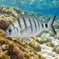
White seabream
Almost always · Sargu
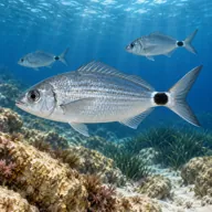
Saddled bream
Almost always · Kaħlija
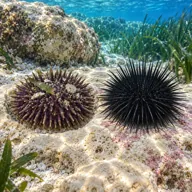
Sea urchins
Almost always · Rizzi
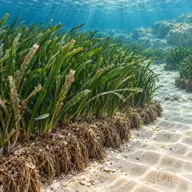
Posidonia meadow
Almost always · Ħaxix il-baħar

Common octopus
Often · Qarnita

Scorpionfish
Often · Skorfna

Mediterranean moray
Sometimes · Morina
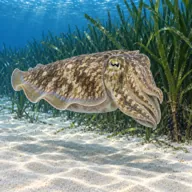
Cuttlefish
Sometimes · Siċċa · Spring
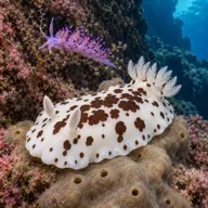
Nudibranchs
Sometimes · Spring
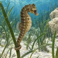
Short-snouted seahorse
Lucky day · Żiemel tal-baħar
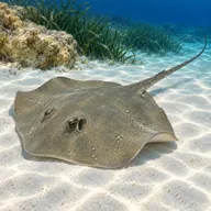
Common stingray
Lucky day · Rajja
Getting in and staying safe
Genuinely reachable from shore, which almost nothing else on this list is. Passenger ferries from Ċirkewwa land at the Blue Lagoon jetty in around twenty-five minutes, and from the landing it is a short walk over rock to a shelf you can step off. Getting a dive kit there involves carrying it on a crowded ferry, so most people still go by dive boat. Seasonal kiosks, deckchairs and portable toilets operate at the lagoon in summer and vanish in winter. No car access anywhere on Comino.
- Heavy boat traffic and propellers, the main risk by a wide margin
- Swimmers and snorkellers directly overhead
- Fine sand that silts out instantly with poor buoyancy
- Sharp limestone and urchins at the water's edge
- Sunburn and heat exhaustion on the surface interval
- Mauve stinger jellyfish blooms in late summer
- Crowded, awkward kit-up on rock with no shade
A bit of history
Comino was largely uninhabited through most of its history, used for grazing, quarantine and hunting, and Santa Marija Tower on the south coast was built in 1618 under Grand Master Alof de Wignacourt to watch the channels. The lagoon itself is a drowned channel cut between the two islets in the upper coralline limestone, and its white sand is the ground-down product of that same rock and of shell debris.
Divers say
Sign in to rate this site and leave a note for the next diver.
- No reviews yet. First one gets bragging rights.
Further reading: Calypso SAC, Blue Lagoon · Dive Shack Malta, Blue Lagoon · PADI, Comino Blue Lagoon dive site · Snorkeling Report, Blue Lagoon habitat description