Gozo
Wardija Point
A near vertical and sometimes overhanging wall on Gozo's west coast, drilled with holes and fissures and piled with boulders below, tucked under a headland with a Punic sanctuary carved into it.
Sea conditions
Excellent right now
Flat, sheltered and calm
Forecast for the site, updated 01:33 AM
- Waves
- 0.3 m
- from SE
- Wind
- 8 km/h
- SSW, gusts 14
- Swell
- 0.2 m
- 5 s period
- Sea temp
- 28 °C
- air 27 °C
Next 7 days
Sunrise 06:47, sunset 19:06
Exposed to wind and swell from: SW (225°), W (270°), NW (315°). Straightforwardly a west coast site: a westerly makes it uncomfortable and adds current, and the usual advice from local guides is to watch the flow whenever there is any west in the wind. An easterly flattens it completely. Visibility runs twenty to forty metres, often on the higher end because the water here is deep and clean. Best season: May to October. Late summer gives the best chance of amberjack along the wall, and September usually offers the most settled westerly-free days..
The dive
Wardija Point is the blunt headland that separates Dwejra from the long western cliffs running down towards Xlendi, and it gives you one of the best walls on that side of the island. The rock comes down close to vertical from the surface and in places tilts back over you, which makes for beautiful photographs and a slightly disorienting sense that the cliff is leaning in.
The face is full of holes, cracks and shallow fissures, and that is the whole point of the dive. Every one of them has something living in it. Moray heads, scorpionfish hunched on ledges, spiny lobster antennae feeling their way out of the dark, octopus dens with their neat scatter of shell fragments outside. Lower down the wall gives way to enormous boulders that have peeled off the cliff over the centuries and stacked themselves into caverns and swim-throughs you can nose into without ever losing sight of daylight.
Most dives run twenty five to thirty metres along the boulder line, but the ground continues well past forty if you have the plan for it. Look outward now and then: amberjack come through here in numbers in late summer.
A rewarding, structure-heavy dive that works far better slowly than fast.
- An overhanging wall that leans out above you
- Fissures and holes packed with moray, lobster and scorpionfish
- Caverns and swim-throughs formed by house-sized fallen blocks
- Amberjack passing along the wall in late summer
- A Punic rock-cut sanctuary on the headland directly above the site
Typical plan
Live drop at the wall, descend to twenty five to thirty metres along the boulder line, work in one direction with the rock on your shoulder for twenty minutes, then turn and come up the face slowly, checking every hole on the way. Finish with a safety stop hanging off the wall at five metres and an SMB up before you leave it. Forty five to fifty minutes, single 15 litre on nitrox 32, average depth around twenty two metres, torch for the fissures.
What the bottom looks like
- 1Near vertical face, overhanging in places10 m deep · 15 m out
- 2Band of small holes and fissures full of life20 m deep · 35 m out
- 3Fallen boulders forming caverns27 m deep · 65 m out
- 4Swim-throughs between stacked blocks33 m deep · 85 m out
- 5Ground continuing below the usual turn depth40 m deep · 115 m out
Vertical Coralline limestone giving way to a slope of very large fallen boulders, with pockets of coarse sand and rubble collecting between them.
Who you might meet
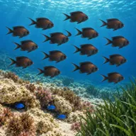
Mediterranean damselfish
Almost always · Kahlija
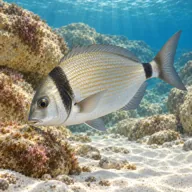
Two-banded bream
Almost always · Sargu
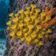
Yellow cluster anemone
Almost always

Moray eel
Often · Morina

Scorpionfish
Often · Skorfna

Common octopus
Often · Qarnit
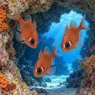
Mediterranean cardinalfish
Often · Re tat-trilji
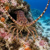
Spiny lobster
Sometimes · Awwista
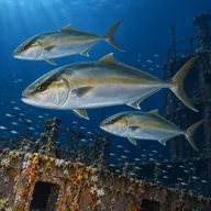
Greater amberjack
Sometimes · Accola · Late summer

Dusky grouper
Sometimes · Cerna
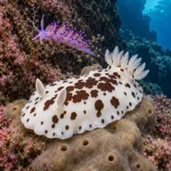
Nudibranchs
Sometimes · Spring
Getting in and staying safe
Boat only, most often from Xlendi or Dwejra on the west side, or a longer run round from Mgarr. No permits or fees apply. Skippers work along the wall rather than anchoring, so expect a live drop and a live pick up, and agree a direction of travel before you go in. There is no shore access under these cliffs and nowhere to climb out, so an SMB is standard rather than optional. Xlendi is the nearest place for fills, food and toilets.
- Current picks up noticeably in western winds and around the point itself
- Overhanging wall makes a direct ascent impossible in places
- Depth continues past forty metres below the boulder line
- Swim-throughs between boulders with silt and limited space
- No shore exit on this coast, so losing the boat is serious
- Live boat drops and pick ups mean a strict surface marker discipline
- Lost fishing gear caught on the wall
A bit of history
The headland above the site, Ras il-Wardija, holds one of the more intriguing archaeological sites on Gozo: a Punic rock-cut sanctuary carved into the ridge, with a rectangular chamber, niches and a cistern, thought to date from around the third to second century BC and used into the Roman period. The name itself comes from the Maltese for a lookout post, which is exactly what this cliff has been for anyone watching the western approaches. Underwater there is no wreck, only Coralline limestone that has been shedding blocks into deep water for a very long time.
Divers say
Sign in to rate this site and leave a note for the next diver.
- No reviews yet. First one gets bragging rights.
Further reading: Divers Guide, Wardija Point · Visit Gozo, Wardija Point · Atlantis Gozo, Wardija Point