Malta
Tent Peg Wreck
The flattened remains of an unnamed steel cargo steamer in Marsamxett Harbour, named for the thousands of tent pegs that are all that survives of its cargo. Silty, sheltered and only for people who enjoy poking about.
Sea conditions
Excellent right now
Flat, sheltered and calm
Forecast for the site, updated 02:18 AM
- Waves
- n/a
- Wind
- 3 km/h
- SSW, gusts 6
- Swell
- n/a
- Sea temp
- n/a
- air 25 °C
Next 7 days
Sunrise 06:46, sunset 19:04
Exposed to wind and swell from: NE (45°). Well inside Marsamxett Harbour, so wind and swell are barely a factor and this is a classic foul-weather fallback. Only a strong north easterly pushing into the harbour mouth makes any difference at the surface. The real variable is not weather but visibility, which is poor on a good day. Best season: All year, and most useful in winter, ideally after a settled spell rather than after rain.
The dive
Calling this a shipwreck is generous. Very little structure is left standing, so what you actually dive is a wreckage site: ribs and plating worked into the silt in a shallow valley on the harbour floor between Ta' Xbiex and Manoel Island, at fifteen to twenty metres. Nobody knows the ship's name. What is known is her cargo, because the seabed is strewn with tent pegs, which is how local divers labelled her decades ago and the name has never been improved on.
The seabed is fine white silt over sand and it undulates gently, which is a polite way of saying that one careless fin kick will end the dive for everyone behind you. Visibility in this part of Marsamxett is often poor to start with. Go slowly, stay off the bottom, and treat good buoyancy as the entry requirement rather than the certification card.
So why bother? Because it is sheltered when nothing else is, it is close to Carolita and the rest of the Marsamxett dives so it slots neatly into a bad-weather day, and because there is a surprising amount of life crowded onto the little structure that remains. It is a rummage dive, and it is honest about that.
- Tent pegs scattered across the seabed, the only clue to an unnamed ship
- Sheltered enough to dive when the open coast is written off
- Pairs naturally with the Carolita barge in one harbour day
- A buoyancy test disguised as a wreck dive
Typical plan
Enter at Ta' Xbiex, drop early and swim out on a compass heading rather than on the surface so you can read the bottom. Work the wreckage at fifteen to twenty metres for twenty five minutes, hovering well clear of the silt, then either turn back the way you came or continue north east to the Carolita barge if your gas and the plan allow. Forty five to fifty minutes on a single 12 litre, air is plenty at this depth. A torch helps in murky water, a reel or a clear compass plan is more important, and a DSMB goes up before you leave the bottom because the yachts above are not looking for bubbles.
What the bottom looks like
- 1Main wreckage, frames and plating in the silt17 m deep · 260 m out
- 2Tent peg scatter, the cargo that named the site19 m deep · 300 m out
- 3Deepest point of the small valley20 m deep · 330 m out
- 4Line back north east towards the Carolita barge16 m deep · 380 m out
Undulating fine white silt over sand, soft enough that the wreckage is half swallowed by it.
Who you might meet
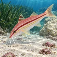
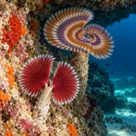
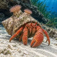


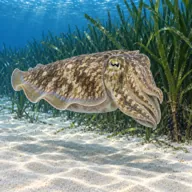
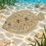
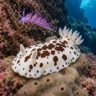

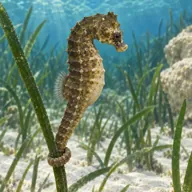
Getting in and staying safe
Easiest from the Ta' Xbiex seafront, where you can park along the marina road and get in from the low rock and steps, then swim out and north east to the site. The alternative is to dive it as an extension from the Carolita barge off Manoel Island and swim south west into the small valley. Neither is a short or scenic surface swim, which is why shore access is rated hard. Cafes and toilets along Ta' Xbiex and Gzira are close by. Yacht marinas either side mean you are swimming among moorings and berth traffic the whole way.
- Heavy yacht and small boat traffic overhead, a DSMB is mandatory
- Poor visibility, frequently a few metres and worse after rain
- Fine silt that goes up instantly and does not settle
- Disorientation in low visibility over a featureless silt bottom
- Sharp corroded plating and protruding metal
- Discarded lines, mooring chain and fishing tackle
- Harbour water quality after storms or heavy runoff
- Long surface swim from Ta' Xbiex with kit
A bit of history
The vessel is an unidentified steel cargo steamer and no reliable record of her name, tonnage or loss date appears in the usual sources. Marsamxett Harbour was a Royal Navy anchorage and a bombing target through the Second World War, and its floor holds a mix of war losses, scuttlings and forgotten commercial hulls, of which this is one. The tent pegs suggest a military or supply cargo, but that remains inference rather than evidence.
Divers say
Sign in to rate this site and leave a note for the next diver.
- No reviews yet. First one gets bragging rights.
Further reading: Malta Dive Sites: Tent Peg Wreck · Malta Dive Sites: Valletta and Marsamxett area · Scuba Diving: Malta's wartime shipwreck graveyard