Malta
X127 Lighter
A little WWII fuel lighter sitting upright on a harbour slope, bow shallow enough for a first wreck dive and stern deep enough to feel like a proper one. Shore access, five minutes of finning, and a hull that has been quietly turning into a reef since 1942.
Sea conditions
Excellent right now
Flat, sheltered and calm
Forecast for the site, updated 02:18 AM
- Waves
- n/a
- Wind
- 3 km/h
- SSW, gusts 6
- Swell
- n/a
- Sea temp
- n/a
- air 25 °C
Next 7 days
Sunrise 06:46, sunset 19:04
Exposed to wind and swell from: NE (45°). About as sheltered as Malta gets. Tucked deep inside Marsamxett Harbour, the site shrugs off the prevailing northwesterly and stays diveable when the north and west coasts are unusable. A strong gregale from the northeast can push chop up the harbour and drop visibility, and heavy rain flushes silt and runoff into the creek. Best season: Year round, and a reliable fallback when winter northwesterlies close everything else. Late spring through autumn gives the best visibility and warmest water, with September and October often the clearest..
The dive
Most divers meet the X127 before they can pronounce her name, and for years nobody could: she was the Carolita, or the Coralita, or just the barge off Manoel Island. Whatever you call her, she is one of the friendliest wrecks in Malta. Twenty four metres of riveted steel lie bow-up on a gentle slope inside Marsamxett Harbour, the bow at around five metres and the stern down near twenty two, which means one wreck can serve a nervous Open Water diver and a slightly bored instructor on the same dive.
The swim out from the shore takes five to seven minutes over an unremarkable rubbly bottom, and then the hull materialises, usually earlier than you expect. She is remarkably whole. You can follow the deck line from the spoon-shaped bow, peer at the pump gear forward, drop through the openings amidships where the fuel tanks used to be, and find the old Tangye engines still recognisable in the engine space. A power cable runs across her like a stray bootlace.
Visibility is the catch. This is a working harbour, the bottom is fine silt, and one careless fin kick turns a pleasant dive into brown soup for everyone behind you. Go slow, keep your feet up, and the wreck rewards you with nudibranchs on the plating, fireworms grazing the rails, and an octopus in a hole it has clearly held for years.
Because she is shallow, sheltered and shore-accessible, the X127 is also a perfect night dive and a genuinely good site for a second wreck ever, rather than a first one that scares people off diving wrecks for good.
- A complete little WWII wreck you can reach from the shore in a single tank
- Bow at five metres and stern at twenty two, so one wreck suits mixed groups
- Tangye engines and blast damage that tell the story of how she died
- Reliable macro life: nudibranchs, fireworms and resident octopus
- Diveable in the northwesterly gales that shut the rest of Malta
Typical plan
Single 12 litre of air is plenty. Surface swim or shallow transit out along the drop-off, drop to the bow at five metres, then work aft and down the slope to the stern at twenty two. Spend your deepest ten minutes around the engine space and stern, then climb the hull forward, lose depth naturally over the bow, and use the shallow return leg as your safety stop while you hunt nudibranchs on the plating. Thirty five to fifty minutes is normal. Keep buoyancy tight, fin frog-kick style so you do not silt the place out, and surface close to the shore rather than mid-creek because of boat traffic.
What the bottom looks like
- 1Rubble drop-off you follow right to find the wreck9 m deep · 100 m out
- 2Spoon bow of the X127 with bollards and pump gear5 m deep · 140 m out
- 3Blast opening amidships where the fuel tanks burned14 m deep · 155 m out
- 4Collapsed plating on the port side16 m deep · 162 m out
- 5Engine space with the old Tangye engines19 m deep · 172 m out
- 6Stern, the deepest point of the dive22 m deep · 182 m out
- 7Silty harbour bottom off the stern24 m deep · 205 m out
Rock and rubble near shore giving way to a soft silt and sand slope that the wreck rests on, so anything you touch becomes a cloud.
Who you might meet
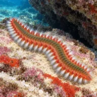
Bearded fireworm
Almost always · Dudu tan-nar
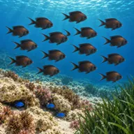
Damselfish
Almost always · Kaħlija
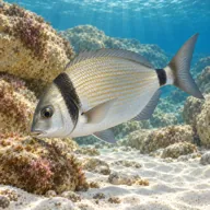
Two-banded bream
Almost always · Sargu
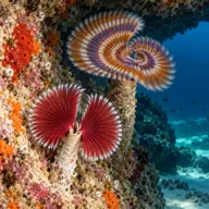
Tube worms and encrusting sponges
Almost always
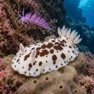
Nudibranchs
Often · Bugharwien tal-bahar · Best spring and early summer

Common octopus
Often · Qarnit

Mediterranean moray
Often · Morina

Scorpionfish
Often · Ċippullazza
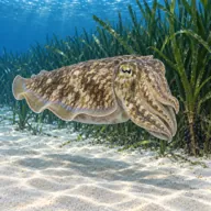
Common cuttlefish
Sometimes · Siċċ · Spring
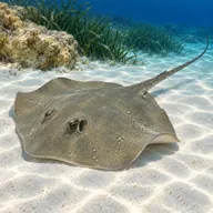
Common stingray
Sometimes · Bokkatura

Cardinalfish
Sometimes · Re tat-trilji
Getting in and staying safe
Drive onto Manoel Island over the bridge from Gzira and park along the road near the marina and the boatyards. Kit up at the car, walk down to the low rocky shore at the head of Lazzaretto Creek and step or slide in from the ledges, which are slippery when wet and worth a quick recce before you are in kit. Exit is at the same spot, so take a bearing on a landmark before you descend. There is no ladder and no shade, and the nearest toilets, cafes and dive shops are across the water in Gzira and Sliema, two minutes by car. The swim to the wreck is on the surface for most groups: drop at the drop-off and follow it right, and the wreck appears at around ten metres.
- Busy harbour: ferries, yachts, RIBs and the Valletta water taxis pass close, so surface with a marker and listen before you ascend
- Fine silt on and around the wreck, easily stirred into near-zero visibility
- Baseline visibility is often only 3 to 10 metres, less after rain or heavy boat movement
- Discarded fishing line and monofilament snagged on the rails and cable
- Stern at 22 metres can quietly push a relaxed dive into deco territory
- Slippery rock entry and exit with no ladder
- Overhead risk if you penetrate the hull openings without training
- Harbour runoff after storms, so give it a day or two before diving post-downpour
A bit of history
The X-lighters were a rush job: roughly two hundred flat-bottomed landing craft built in Britain in 1915 to put troops ashore at Gallipoli, nicknamed Black Beetles for their stubby shape and dark paint. X127 was one of them, about 24 metres long with a 7 metre beam and the distinctive spoon bow made for running onto a beach. After the First World War she was retained at Malta's Victualling Yard and put to less glamorous work carrying water and later fuel. By the Second World War she was serving the Royal Navy's 10th Submarine Flotilla out of Lazzaretto, ferrying shale oil to the submarines that were making life difficult for Axis convoys. She was destroyed in the spring of 1942 during the aerial siege of Malta while moored at the wharf, the damage concentrated around the port side amidships where the tanks sat, and she was written off as a war loss by 1946. Accounts differ on the exact day and on whether a bomb or a torpedo finished her, which is fitting for a vessel that spent sixty years without a name: a 2003 survey first put her down as X131, and further work in 2006 settled on X127.
Divers say
Sign in to rate this site and leave a note for the next diver.
- No reviews yet. First one gets bragging rights.
Further reading: Underwater Malta: X-Lighter 127 virtual museum record · New Dimension Scuba: the X127 Lighter dive guide · Calypso Sub-Aqua Club: X127 Lighter / Carolita Barge · Malta Dive Sites: X127 wreck · Wrecksite: X127 record · PADI dive site listing: X127 Lighter / Carolita