Gozo
Sanap Cliffs
A hundred and twenty metres of golden cliff above you and a vertical wall below, with a cavern to poke your torch into and two small reefs flanking the drop. Colour, not fish, is the draw.
Sea conditions
Excellent right now
Flat, sheltered and calm
Forecast for the site, updated 01:47 AM
- Waves
- 0.3 m
- from SE
- Wind
- n/a
- Swell
- 0.2 m
- 5 s period
- Sea temp
- 28 °C
Next 7 days
Exposed to wind and swell from: SE (135°), S (180°), SW (225°). The site sits under a south-facing cliff line and is well sheltered from anything with north or north west in it, which makes it a classic fallback when the whole north coast is blown out. A southerly or a south easterly puts a surge on the wall and makes tying up unpleasant. Visibility is usually excellent, twenty to fifty metres, and afternoon light is much better than morning on this aspect. Best season: April to November. Spring gives the cleanest water and the best chance of the wall to yourself, while late summer brings warmer temperatures and the better odds of amberjack and tuna cruising past..
The dive
The Sanap cliffs are the postcard Gozo everyone photographs from the clifftop path between Munxar and Xlendi. Getting under them is better. The boat ties up on a ledge at roughly eight metres, which makes both the briefing and the safety stop refreshingly civilised, and from there the rock drops away to the west in a proper vertical wall.
The wall is the show. Sponges in orange and yellow, cushions of yellow cluster anemone, soft corals in the shadow lines, and enough overhang that everything looks twice as good with a torch on it. Partway down there is a cavern worth a careful look, and a second cave sits to the east of the mooring ledge with small patches of reef on either side. Most divers turn somewhere around thirty five to forty metres, although the rock keeps going well past that if you have the gas and the ticket.
Fish life is honest rather than spectacular. Octopus in the cracks, nudibranchs for anyone who slows down and looks, cardinalfish hanging in the cave mouths, and now and then a squadron of amberjack or a tuna cutting through above the wall. Photographers do very well here, especially in the afternoon when the sun swings round to light the south-facing rock.
Think of it as a relaxed, colourful, slightly deep wall cruise with good odds of coming home with a picture you like.
- A genuinely vertical wall with sponges and soft corals in full colour
- A cavern and a second cave to explore without committing to a penetration dive
- An eight metre mooring ledge that makes the safety stop effortless
- Reliable shelter when the north coast is closed by wind
- Twenty to fifty metre visibility and beautiful afternoon light
Typical plan
In off the ledge, straight to the lip of the wall and down the face to a turn depth of thirty five to forty metres, then work back up the rock with the wall on your shoulder, dipping into the cavern on the way. Fifteen minutes deep, twenty five minutes shallow, finish on the eight metre ledge under the boat. Nitrox 30 on a single 15 litre suits most plans, run time about fifty minutes, and a torch is essential rather than optional if you want the colour.
What the bottom looks like
- 1Mooring ledge at 8 m, used for the safety stop8 m deep · 15 m out
- 2Lip of the wall, west of the ledge12 m deep · 30 m out
- 3Second cave east of the ledge16 m deep · 40 m out
- 4Cavern set into the wall24 m deep · 50 m out
- 5Sheer face with sponges and soft corals36 m deep · 65 m out
- 6Fallen blocks at the base of the wall45 m deep · 100 m out
Vertical and overhanging Coralline limestone encrusted with sponges and anemones, with fallen blocks and coarse sand collecting at the foot of the wall.
Who you might meet
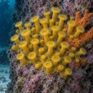
Yellow cluster anemone
Almost always
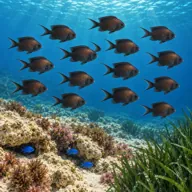
Mediterranean damselfish
Almost always · Kahlija
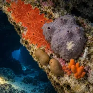
Bath and encrusting sponges
Almost always · Sponża

Common octopus
Often · Qarnit
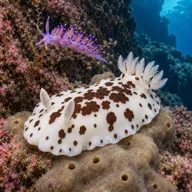
Nudibranchs including Discodoris
Often · Spring
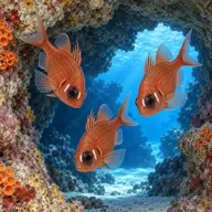
Mediterranean cardinalfish
Often · Re tat-trilji

Scorpionfish
Often · Skorfna
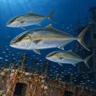
Greater amberjack
Sometimes · Accola · Late summer

Moray eel
Sometimes · Morina
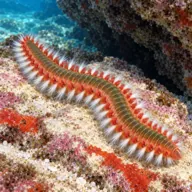
Bearded fireworm
Sometimes · Busuf · Summer
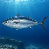
Atlantic bluefin tuna
Lucky day · Tonn · Summer
Getting in and staying safe
Boat only. It is a short run from Xlendi and a comfortable one from Mgarr, and boats tie to the ledge at around eight metres rather than dropping an anchor on the reef. No permits or fees apply. There is nowhere to get out along this coast, so bring what you need with you and keep an eye on the boat. Xlendi, ten minutes away, has cafes, toilets and fills, and is the obvious place to sit out a surface interval.
- Very easy to creep deeper than planned on a wall with no bottom in sight
- Chop builds quickly on this exposed south coast, making the boat ladder awkward
- Variable current, usually mild but occasionally noticeable off the point
- Overhead rock in the cavern and the second cave, with silt on the floor
- Nowhere to exit along the cliff if you get separated from the boat
- Boat traffic and tourist tour boats in summer, so always fly a flag and deploy an SMB
- Jellyfish, including mauve stingers, drifting in during late summer
A bit of history
No wreck, no ship, no war story. The cliffs themselves are the history: Lower Coralline Limestone standing where the softer beds above have long since been stripped off, cut back by the sea into the ledges, caverns and the famous arch of Dawra tas-Sanap just around the corner. The name Sanap belongs to the stretch of coast in the limits of Munxar, which has been grazing land and rabbit country for centuries and only became a tourist landmark once everyone started walking the clifftop at sunset.
Divers say
Sign in to rate this site and leave a note for the next diver.
- No reviews yet. First one gets bragging rights.
Further reading: Divers Guide, Sanap Cliffs · Visit Gozo, Dawra tas-Sanap · Malta Dives, Sanap Cliffs · DiveBoat Malta, Sanap Cliffs