Qawra Point · Malta
North Reef & Arch
Swim straight out north from Qawra Point and the rock slopes to ten metres before stepping down over a small reef, with a proper little arch at around 18 metres that divers can fly through. Seagrass, sand and good navigation practice.
Sea conditions
Good right now
Some chop (0.4 m ESE)
Forecast for the site, updated 01:45 AM
- Waves
- 0.4 m
- from ESE
- Wind
- n/a
- Swell
- 0.4 m
- 5 s period
- Sea temp
- 29 °C
Next 7 days
Exposed to wind and swell from: NW (315°), N (0°), NE (45°), E (90°). Fully exposed to the northern half of the compass, so it needs a southerly or southwesterly to be pleasant, and anything with north or northwest in it will make both the swim and the exit unpleasant. Visibility is typically 15 to 25 metres, better when the seagrass has not been stirred. Mild current can run along the reef edge. Best season: May to October, with calm settled summer days giving the best light through the arch..
The dive
This is the dive that turns Qawra Point from a training bay into somewhere worth a second visit. Head north from the entry and the rocky ground shelves out gently to about ten metres, where the reef edge forms a small wall dropping onto sand at fifteen with Posidonia meadows crowding around it.
Towards the western end of that reef there is an arch, more of a short tunnel really, big enough to swim through comfortably and sitting at roughly eighteen metres. A narrow sand path runs between the seagrass and takes you under it, coming out onto another sand field at around twenty-two metres. It is a small feature but it is a genuinely satisfying one, and on a sunny day the view back through it is the shot everyone takes.
Keep swimming north and the seagrass takes over almost completely until a deeper reef shows up at around thirty metres, which is where the site quietly stops being an easy dive and starts needing a plan.
The eastern end of this shallow reef runs back towards Fra Ben Cave, so the neat way to do it is a loop: out over the reef, through the arch, back along the reef edge and into the cave for the shallow finish.
- A swim-through arch at 18 metres that you can genuinely fly through
- Sand path threading between Posidonia meadows, like a hedge maze
- Easy loop back to Fra Ben Cave for a shallow finish
- Good navigation practice without real consequences
- Cuttlefish and octopus along the reef edge
Typical plan
Out on the surface or on a compass bearing due north, drop onto the rock and follow it out to the reef edge at 10 metres. Step down the small wall to the sand at 15, work west along the edge to find the arch at 18, through it and out onto the outer sand at 22. Turn there. Come back over the reef and finish shallow, ideally ducking into Fra Ben Cave on the way in. Around 45 to 50 minutes on air or nitrox 32, maximum depth 22 metres, DSMB up before you surface anywhere near the boat lane.
What the bottom looks like
- 1Reef top where the rock levels off10 m deep · 150 m out
- 2Small wall stepping down off the reef14 m deep · 235 m out
- 3Sand pocket ringed by seagrass15 m deep · 260 m out
- 4Narrow sand path between Posidonia meadows17 m deep · 280 m out
- 5The arch, a short swim-through tunnel18 m deep · 295 m out
- 6Outer sand field beyond the arch22 m deep · 355 m out
- 7Seagrass running north towards the deeper reef22 m deep · 400 m out
Rocky reef and ledge inshore, giving way to sand patches surrounded by dense Posidonia seagrass.
Who you might meet
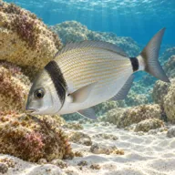
Two-banded bream
Almost always · Sargu
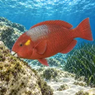
Mediterranean parrotfish
Almost always · Marzpan
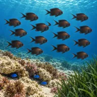
Damselfish
Almost always · Ċawl
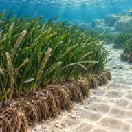
Posidonia meadows
Almost always · Alka

Common octopus
Often · Qarnit
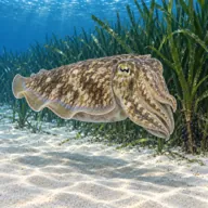
Common cuttlefish
Often · Siċċa · Spring
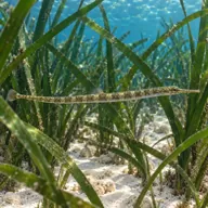
Pipefish
Often · Gremxula tal-baħar

Mediterranean moray
Sometimes · Morina

Red scorpionfish
Sometimes · Ċippullazza
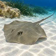
Common stingray
Sometimes · Bokkatura
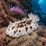
Nudibranchs
Sometimes · Spring
Getting in and staying safe
Same entry as the rest of the north side: park on the Qawra Point promenade or near the aquarium, walk around 150 metres, and get in via the rock-cut pool and shelf below the tower. From there it is a surface swim north followed by a descent onto the sloping rock, or a submerged navigation exercise if you would rather practise your compass. Getting from the sheltered basin into open water is the crux in any swell. Cafes, restaurants and public toilets are all within a short walk. Some centres run it as a boat drop instead, which saves the swim.
- Boat traffic offshore of the point, a DSMB is essential on ascent
- Navigation, the seagrass looks identical in every direction
- Swell and surge at the entry and exit in any northerly component
- Temptation to continue north to the 30 metre reef beyond your plan
- Slippery rocks at the entry
- Fishing line caught on the reef edge
- Silt-out risk on the sand path under the arch if a group bunches up
A bit of history
No wreck, no legend. The reef is a submerged limestone ledge running off the Qawra headland, undercut in places by wave action, and the arch is simply the surviving roof of a section where the rock was eaten out from both sides. The Posidonia meadows around it are the real heritage feature: slow-growing seagrass beds that are a protected habitat across the Mediterranean and take decades to recover from an anchor scar.
Divers say
Sign in to rate this site and leave a note for the next diver.
- No reviews yet. First one gets bragging rights.
Further reading: Malta Dive Sites: North Reef & Arch · New Dimension Scuba: Qawra Point · Divers Guide: Qawra Point North · Malta Tourism Authority Dive Site Report 17: Qawra Point North