Malta
HMS St. Angelo
A twenty four metre Royal Navy tug, mined in May 1942 while sweeping, now sitting upright and tidy at fifty four metres just outside Grand Harbour. Small, complete and charming, with one large catch: she is parked in the shipping channel.
Sea conditions
Good right now
Some chop (0.5 m E)
Forecast for the site, updated 01:45 AM
- Waves
- 0.5 m
- from E
- Wind
- n/a
- Swell
- 0.5 m
- 5 s period
- Sea temp
- 29 °C
Next 7 days
Exposed to wind and swell from: N (0°), NE (45°), E (90°), SE (135°). Just outside the harbour entrance with Malta's coast to the west, so the northeast and east quadrant is what matters. A gregale makes it impossible. In a westerly or southwesterly the water off Valletta flattens and clears nicely. Visibility is generally good, twenty to thirty metres, though harbour outflow can knock it back after heavy rain. Best season: May to October, subject entirely to when the harbour approach is closed to traffic..
The dive
Everything about this wreck is likeable except her address. St Angelo is a compact little tug sitting bolt upright on clean sand at fifty four metres, small enough that you can circle her several times in a single bottom time and actually understand the whole vessel. Wheelhouse, towing gear, deck fittings, the lot, all in one readable package with fish hanging off every corner.
The complication is that she lies right in the approach channel for Grand Harbour, with cruise ships, ferries and commercial traffic passing over the top. That is not a theoretical hazard. Most operators will only run this dive when the harbour is closed to traffic on specific dates, and anyone offering it casually on a busy Tuesday is doing something you should not be part of.
At fifty four metres she is also one of the more accessible deep wrecks on this list. A normoxic trimix diver with a decent kit and a sensible plan gets a satisfying twenty five minutes down there. She is the sort of wreck that makes people fall for technical diving.
- Small enough to take in completely, upright and very photogenic
- Fifty four metres, which is the shallow end of Malta's serious deep wrecks
- A harbour tug turned minesweeper, a proper siege era story
- Ten minutes from the quay when the timing works
Typical plan
Normoxic trimix, around twenty to twenty five minutes at fifty four metres. Down the shot to the wheelhouse, a slow lap of the hull at deck level, a second lower lap along the sand to see the shape of her, then back up the line. Thirty to forty five minutes of decompression on fifty percent nitrox and oxygen. Big delayed surface marker on the way up, and a boat that does not wander.
What the bottom looks like
- 1Wheelhouse and upper deck49 m deep · 12 m out
- 2Bow and forward fittings52 m deep · 20 m out
- 3Stern, towing gear and rudder53 m deep · 34 m out
- 4Clean sand around the hull54 m deep · 50 m out
Flat sand with a light silt layer, the small upright hull standing out sharply against it.
Who you might meet
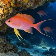
Swallowtail sea perch
Almost always · Pixxiroża
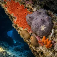
Encrusting sponges
Almost always · Sponża
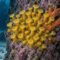
Yellow cluster anemone
Almost always
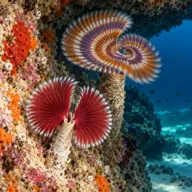
Tube worms
Almost always
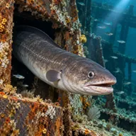
Conger eel
Often · Gringu

Red scorpionfish
Often · Ċipullazza

Dusky grouper
Sometimes · Ċerna

Common octopus
Sometimes · Qarnit
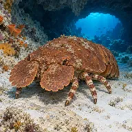
Slipper lobster
Sometimes · Ċikala

Common stingray
Sometimes · Boll
Getting in and staying safe
Boat only, and realistically only on days when the harbour approach is closed to commercial traffic. Talk to a technical centre in Sliema or Valletta and be led by their advice on timing, because the scheduling is the whole game here. The run out is short, which is a bonus, but you want a boat that will stay directly over you throughout, a shot line, and a very visible surface marker on ascent. Check the current Heritage Malta permitting position with your centre before booking.
- Commercial shipping directly overhead: this is the single biggest risk on the site
- Fifty four metres requiring trimix and a real decompression plan
- Snagged fishing line and lost tackle around the wreck
- Silt on and around the hull that clouds up quickly
- Open water decompression in a busy channel, so a large marker is essential
- Possible unexploded ordnance given how she was lost
A bit of history
St Angelo began life as a tug and spent her Royal Navy career as a harbour workhorse, ferrying people and stores from the base at Fort St Angelo out to warships lying in Grand Harbour and around the other Maltese ports. During the war she was put to rescue work, towing and eventually minesweeping, which is what the siege did to almost every small craft on the island. On 30 May 1942, in the same run of weeks that claimed the drifters Eddy and others off Valletta, she struck a mine and sank just outside the harbour she had served. She is roughly twenty four metres long and lies upright on sand at fifty four metres, about a kilometre and a half off the Grand Harbour entrance.
Divers say
Sign in to rate this site and leave a note for the next diver.
- No reviews yet. First one gets bragging rights.
Further reading: Wrecksite entry for HMS St Angelo · Techwise Malta dive notes on HMS St Angelo · Dive Systems Malta: HMS St Angelo · Malta Dive Sites: HMS St Angelo