Malta
Devil's Reef
A boat dive under the cliffs at Malta's northwestern corner, where a bright shallow plateau ends without warning in a wall that falls past 50 metres and keeps on going.
Sea conditions
Excellent right now
Flat, sheltered and calm
Forecast for the site, updated 01:50 AM
- Waves
- 0.3 m
- from SE
- Wind
- n/a
- Swell
- 0.2 m
- 5 s period
- Sea temp
- 29 °C
Next 7 days
Exposed to wind and swell from: W (270°), NW (315°), N (0°), SW (225°). The corner needs calm. Guides consistently flag chop and current when the wind is in the northwest or southwest, and with any swell running the skipper will not want to hold station near the cliff. Days with the wind in the east or southeast are the ones to watch for. Visibility ranges widely, roughly 10 to 40 metres, with 25 a fair average. Best season: June to October. Late summer brings the settled seas and the best chance of finding the big predators working along the drop..
The dive
Ras il-Qammieħ is the blunt western end of the Marfa ridge, and the reef hanging off it has one of the most satisfying shapes in Malta. The top is a plateau in 4 to 6 metres, sunlit and cut with little gullies, and it runs on far enough that you could spend an entire dive up there without ever looking over the edge.
Swim southwest and the plateau stops. The wall below drops in one sweep to somewhere around 45 to 50 metres, then a sand slope carries on into the dark past 70. Along the shallower part there are caves and caverns and a swim-through at roughly 25 metres, plus an old cavity on the southern side with stalactites still hanging from the roof, left over from a time when this rock was dry land. A large old grappling anchor lies wedged below the drop as a bonus.
It is a genuine pelagic site. Barracuda and dentex are regulars, amberjack come through in packs, tuna cruise past in the blue and people do occasionally get a big ray out there. You are also a long way from any exit: this is boat access only, the surface gets choppy in a hurry and the current on the corner deserves real respect.
- A wall that falls from 18 metres to 50 in one unbroken sweep
- Swim-through at about 25 metres on the shallower section
- Stalactites in a drowned cave on the southern side
- Barracuda, dentex and amberjack hunting off the edge
- A bright, gully cut plateau at 4 to 6 metres for the shallow half of the dive
Typical plan
The recreational version drops on the plateau, swims southwest to the lip, then runs the wall at 25 to 30 metres with the swim-through as the turning point, before climbing back onto the shallow top for the last twenty minutes among the gullies. Forty to forty five minutes on nitrox 32, surface marker deployed before leaving the reef because the drift can be substantial. The technical version goes over the edge to 45 or 50 metres on trimix for a short bottom time, staging deco on the wall and finishing the shallow stops drifting in the blue with the boat following the marker. Either way, agree the turn point before you get in.
What the bottom looks like
- 1Sunlit plateau with gullies at 4 to 6 m5 m deep · 80 m out
- 2Lip of the main wall18 m deep · 170 m out
- 3Swim-through at around 25 m25 m deep · 195 m out
- 4Old cavern with stalactites on the southern side30 m deep · 215 m out
- 5Large old grappling anchor wedged below the drop48 m deep · 275 m out
- 6Sand slope running on beyond 70 m62 m deep · 350 m out
Hard coralline limestone plateau cut by gullies, falling away as a near vertical face to a clean sand slope in the deep.
Who you might meet

Cardinalfish
Almost always · Sultan iċ-ċawl
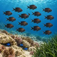
Damselfish
Almost always · Ċawl
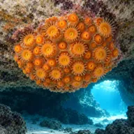
Golden cup coral
Almost always · Qroll tad-dell
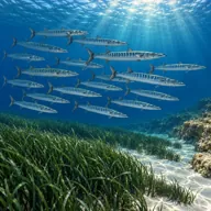
Barracuda
Often · Lizz · Late summer and autumn
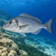
Dentex
Often · Dentiċi

Amberjack
Often · Aċċola · Autumn

Moray eel
Often · Morina

Dusky grouper
Sometimes · Ċerna
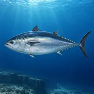
Atlantic bluefin tuna
Sometimes · Tonn · Summer
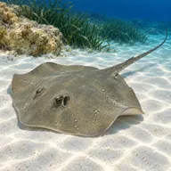
Common stingray
Sometimes · Raja
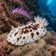
Nudibranchs
Sometimes · Spring
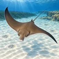
Eagle ray
Lucky day · Ħamiema
Getting in and staying safe
Boat only, and there is no realistic shore alternative: the cliffs above are high and the coastline is unfriendly. Dive boats run out from Ċirkewwa, Marfa and Mellieħa in fifteen to twenty minutes. Most skippers drop you over the shallow plateau to descend rather than straight over the drop, then pick you up on a surface marker wherever the current has taken you. Bring everything you need with you, including a decent marker and a whistle, because there is nowhere to climb out if the boat has to reposition.
- Strong currents, worst right on the corner itself
- Choppy surface in northwesterly and southwesterly wind
- Silt in the caves, visibility can collapse within seconds
- Depth, the wall runs far past recreational limits with no ledge to stop you
- Boat access only, no shore exit anywhere nearby
- Easy to be pushed off the wall into open water, carry a marker and deploy early
A bit of history
The stalactites in the southern cave give the game away. This coast stood above sea level during the last glacial low stand, when the Mediterranean sat far lower and these caverns were dry chambers with water dripping through their roofs. The sea came back and drowned them. The heavy old grappling anchor below the drop-off is a reminder of how many centuries of shipping have had to round this corner, and of how many of them lost gear doing it.
Divers say
Sign in to rate this site and leave a note for the next diver.
- No reviews yet. First one gets bragging rights.
Further reading: Malta Dive Sites, Devil's Reef · Calypso Sub-Aqua Club, Qammieħ Point · Dive Systems Malta, Qammieh Point · Divers Guide, Devil's Reef