Malta
Benghisa Reef
A long ridge of rock about a kilometre off Benghisa Point that runs 1.5 km to the south east, topping out around ten metres and stepping down in drop offs toward fifty. Sporty, current prone, and the best chance of pelagics on this corner of the island.
Sea conditions
Good right now
Some chop (0.5 m E)
Forecast for the site, updated 01:46 AM
- Waves
- 0.5 m
- from E
- Wind
- n/a
- Swell
- 0.5 m
- 5 s period
- Sea temp
- 29 °C
Next 7 days
Exposed to wind and swell from: E (90°), SE (135°), S (180°), SW (225°), W (270°). An offshore reef on the southern side of the island with fetch from most of the seaward sectors. Northerly weather gives it some lee from the land, which is when it usually gets dived. Currents are the real variable and they are not always predictable from the surface. Best season: June to October on settled northerly mornings, when visibility is at its best and the pelagic odds are highest..
The dive
Benghisa Reef is one of those sites that rewards a good skipper more than a good diver. It is a long submerged ridge sitting out in open water off the south east corner of Malta, and where you get dropped decides what kind of dive you have. Shot in near the shallow top and you can potter along a ten to twenty metre reef crest. Drop onto the seaward side and you are looking down a series of steps and overhangs that fall away past forty metres toward fifty and beyond.
The structure is varied in a way the depth numbers do not convey: boulders, overhangs, sandy gullies between rock fingers, and patches of seagrass where the ground flattens. Visibility here is often excellent, twenty five metres being about typical and occasionally much more, and because it stands out in open water it collects fish. Reef species everywhere, morays and octopus in the holes, rays on the sand, and then the reason people actually come, which is the chance of amberjack, dentex or tuna cruising past the drop off with that infuriating casualness.
The catch is that it sits near the approaches to Marsaxlokk Bay and the Freeport, so commercial and fishing traffic is constant, and the current can come on strong and fast with very little warning. This is a dive for people who are comfortable with a negative entry, a drift, and a surface marker deployed well before they leave the bottom. Get it on a calm morning with a clean drop and it is a genuinely excellent Maltese reef dive.
- Drop offs stepping from ten metres down past forty
- The best pelagic odds on Malta's south east corner
- Typical visibility around twenty five metres and sometimes far more
- A 1.5 km ridge, so no two drops give quite the same dive
- Cardinal buoy over a six metre pinnacle at the south east end
Typical plan
Single cylinder with nitrox, or a twinset if you want the deeper face. Negative entry onto the shot, straight down to the reef crest at ten to fifteen metres, then follow the structure down the seaward side to a planned maximum of thirty to forty metres. Work back up the reef as the dive goes on so you finish shallow, deploy a surface marker from the crest, and drift the last ten minutes for a boat pick up. Thirty five to forty five minutes, and watch your depth on the drop off because it will happily take you deeper than you planned.
What the bottom looks like
- 1Shallow reef crest below the drop point10 m deep · 18 m out
- 2Boulder field on the reef shoulder16 m deep · 60 m out
- 3First big step down the reef face28 m deep · 130 m out
- 4Steeper wall section with overhangs40 m deep · 200 m out
- 5Seagrass and rubble on a flatter shelf47 m deep · 260 m out
- 6Sand at the foot of the reef50 m deep · 320 m out
Hard limestone reef with boulders and overhangs, cut by sandy gullies, with seagrass and sand at the base.
Who you might meet
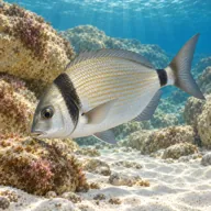
Two banded seabream
Almost always · Sargu
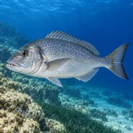
Common dentex
Often · Dentiċi

Mediterranean moray
Often · Morina

Common octopus
Often · Qarnit

Red scorpionfish
Often · Ċippullazza
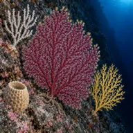
Sponges and gorgonians on the deeper wall
Often

Greater amberjack
Sometimes · Aċċola · Summer and autumn

Dusky grouper
Sometimes · Ċerna

Barracuda
Sometimes · Lizz · Autumn
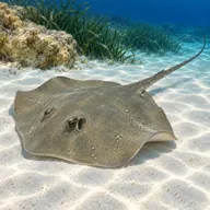
Common stingray
Sometimes · Bumarin
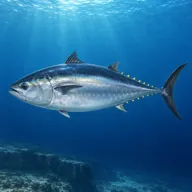
Atlantic bluefin tuna
Lucky day · Tonn · Summer
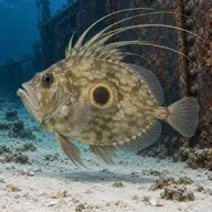
John Dory
Lucky day · Pixxi San Pietru · Winter
Getting in and staying safe
Boat only, roughly a kilometre out from Benghisa Point, and most operators run it from Marsaxlokk or the south east. There is no shore option. Descents are usually on a shot or the anchor line, and the cardinal buoy over the shallow pinnacle at the south east end gives the skipper a reference. Expect the crew to want a surface marker on every buddy pair and to brief a drift pick up.
- Strong and variable currents that can build very quickly
- Heavy commercial and fishing traffic near the Freeport and Marsaxlokk approaches
- Easy depth creep down the drop off toward fifty metres and beyond
- Open water ascents, so a surface marker is not optional
- Snagged fishing line and lost tackle on the reef crest
- No shelter if the weather deteriorates during the dive
A bit of history
No wrecks and no legends, just geology. The reef is a hard limestone ridge left standing when the surrounding seabed was cut lower, the same process that produced the offshore banks along Malta's southern approaches. The historical interest here is all in the water above it: the southern approaches to Marsaxlokk saw heavy air activity in the Second World War, and both the B-24 Liberator and a Douglas A-1 Skyraider lie in deep water in the same stretch of sea.
Divers say
Sign in to rate this site and leave a note for the next diver.
- No reviews yet. First one gets bragging rights.
Further reading: DiveBoat.mt: Benghisa Rock · Divers Guide: Benghajsa Reef · Malta Dive Sites: Benghisa Reef