Malta
Benghisa Point
A rough and ready shore dive on the south coast below Fort Benghajsa, starting in a narrow rocky inlet and working out over Posidonia to twenty metres. There is a good arch close in, and there is a lot of boat traffic just offshore.
Sea conditions
Good right now
Some chop (0.5 m E)
Forecast for the site, updated 01:46 AM
- Waves
- 0.5 m
- from E
- Wind
- n/a
- Swell
- 0.5 m
- 5 s period
- Sea temp
- 29 °C
Next 7 days
Exposed to wind and swell from: SW (225°), S (180°), W (270°), SE (135°). A south coast site facing into the open Mediterranean, so any southerly or south westerly makes the inlet entry dangerous rather than merely awkward. It works best on a settled northerly, when the wind is coming off the land and the point is in the lee. Best season: May to October on a northerly. Winter storms out of the south make the entry and exit unusable..
The dive
This is not a site anybody dives by accident. You park on the exposed headland south of Birzebbuga, walk your kit to a narrow gash in the coast, and either take a giant stride off a concrete platform that is higher than you would like or slither down the rocks. Getting out means climbing, so think about the swell before you think about anything else.
Inside the inlet the bottom is flat rock and gravel at about four metres, gloomy and often murky, and it does not sell the dive. Push out past the mouth and it improves markedly. The rock formations close to shore are worth the trip on their own, including a good arch on the right hand side of the inlet, and beyond them the seabed opens into Posidonia meadow running away to the southwest. Follow that and the depth builds steadily to twenty metres, where the meadow gives way to open sand.
What makes it an advanced dive is not the depth. It is the entry, the exit and the traffic. You are diving just outside one of the busiest commercial harbours in the Mediterranean, with fishing boats and pleasure craft crossing constantly, and surface current here can turn up without warning. Carry a delayed surface marker, deploy it before you come up, and do not be shy about calling it off.
- A proper rock arch within a few minutes of the entry
- Big, healthy Posidonia meadow with good octopus and cuttlefish odds
- Quiet site that you will almost certainly have to yourself
- Dives the same water where the Liberator came down in 1943
Typical plan
Single cylinder or a small twinset, maximum twenty metres, no decompression. Giant stride from the platform, swim out along the inlet at four metres, take in the arch on the right, then head south west over the Posidonia and let the depth build to twenty metres. Turn on thirds or on time, come back on a reciprocal bearing shallower over the meadow, and deploy a surface marker before you leave the bottom. Forty five to fifty five minutes. Save some energy and some breath for the climb out.
What the bottom looks like
- 1Flat rocky and gravel floor inside the inlet4 m deep · 15 m out
- 2Rock arch on the right hand side of the inlet5 m deep · 45 m out
- 3Broken rock formations at the inlet mouth6 m deep · 70 m out
- 4Posidonia meadow taking over the seabed9 m deep · 110 m out
- 5Last step down before the sand19 m deep · 300 m out
- 6Open sand at the turnaround20 m deep · 350 m out
Flat rock and gravel in the inlet, then extensive Posidonia meadow, then open sand beyond twenty metres.
Who you might meet
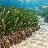
Posidonia meadow
Almost always · Alka
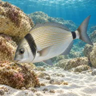
Two banded seabream
Almost always · Sargu

Salema
Almost always · Xilep · Summer

Common octopus
Often · Qarnit

Red scorpionfish
Often · Ċippullazza

Mediterranean moray
Sometimes · Morina
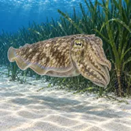
Cuttlefish
Sometimes · Siċċa · Spring
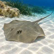
Common stingray on the sand
Sometimes · Bumarin

Barracuda
Sometimes · Lizz · Autumn

Mauve stinger jellyfish
Sometimes · Brama · Spring and autumn
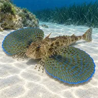
Flying gurnard
Lucky day · Bies · Summer
Getting in and staying safe
Drive south out of Birzebbuga past the Freeport toward the Benghajsa headland and park on the rough ground near the coast. It is a walk in full kit over uneven stone to the inlet, which is a genuine effort with a twinset. Entry is either a giant stride from a high concrete platform or an undignified slide down the rocks, and exit means climbing back out, so plan a buddy handover for fins and weights. No facilities, no shade, no water. Birzebbuga has cafes and toilets a short drive back up the road.
- High concrete platform entry and a climb out over rocks
- Fishing boats and pleasure craft crossing just offshore
- Proximity to the Freeport and Marsaxlokk shipping
- Strong surface current arriving with little warning
- Poor visibility inside the inlet
- Long, awkward walk with kit over uneven ground
- Sea urchins and slippery rock at the entry
A bit of history
The headland above is dominated by Fort Benghisa, built by the British between 1910 and 1912 on the seaward face of the point, which forms the southern arm of Marsaxlokk Bay. An older Bengħajsa Tower stood nearby as part of the coastal watch system of the Order of Saint John. The coast itself is Globigerina and Coralline limestone, and the arch and ledges near the inlet are the usual result of the sea working along the bedding planes. The Liberator bomber ditched off this point in 1943, and its wreck lies offshore in deep water.
Divers say
Sign in to rate this site and leave a note for the next diver.
- No reviews yet. First one gets bragging rights.
Further reading: Malta Dive Sites: Benghisa Point · Wikipedia: Fort Benghisa · Mindat: Il-Ponta ta' Bengħajsa · Visit Malta: shore dive sites