Malta
Armier Bay
A shallow sandy bay on the Marfa ridge with a very large Admiralty pattern anchor lying in about five metres and its chain vanishing under the seagrass. Not a spectacular dive, but a genuinely pleasant shallow potter with Comino on the horizon.
Sea conditions
Excellent right now
Flat, sheltered and calm
Forecast for the site, updated 02:29 AM
- Waves
- n/a
- Wind
- 4 km/h
- S, gusts 8
- Swell
- n/a
- Sea temp
- n/a
- air 25 °C
Next 7 days
Sunrise 06:47, sunset 19:05
Exposed to wind and swell from: N (0°), NE (45°), NW (315°). Wide open to the channel between Malta and Comino, so any northerly component puts chop straight into the bay and turns the shallow sand to milk. It comes good quickly once the wind swings south or west, and in a southerly it can be beautifully flat. Best season: June to September for warmth and clarity, though the bay is at its quietest for divers in late spring and early autumn..
The dive
Armier is a holiday beach first and a dive site a long way second, and there is no point pretending otherwise. It is a broad sandy bay on the north side of the Marfa ridge, lined with beach bars and boathouses, looking across the channel at Comino and Gozo. The water is shallow, warm and usually bright, and for most of the summer the bay belongs to swimmers and small boats.
The reason a diver goes is the anchor. It is an old Admiralty pattern piece, considerably bigger than the one at Anchor Bay, sitting in around five metres with a length of chain running away from it that disappears under the Posidonia. Finding it is part of the exercise, since there is no line and no obvious landmark, and once you have it there is not much else structural in the bay. Around it the seabed alternates sand, seagrass meadow and low rocky patches out to about eight metres.
What it is good for is exactly that: a quiet second dive, a shallow navigation exercise, a snorkel with a tank, or a night dive when you cannot face a drive to the other end of the island. The seagrass holds more life than it looks like it does, and on a still evening with the light low over Comino it is a lovely place to be in the water. Online information on the site is thin, so ask a local centre before you commit an afternoon to it.
- A big Admiralty anchor at a depth where you can stay all day
- Easy walk in entry straight off a sandy beach
- Healthy Posidonia meadow worth searching slowly
- Beach bars and an actual toilet, which is not nothing
- Views of Comino from the surface interval
Typical plan
Single cylinder, maximum eight metres, no decompression to think about. Walk in off the beach, take a compass bearing out into the bay and search the five metre contour for the anchor and its chain. Work the seagrass edge outward to seven or eight metres, then loop back in on a reciprocal. An hour goes by easily and you will still have gas left. Bring a marker buoy for the boat traffic and a torch for peering under the weed.
What the bottom looks like
- 1Open sand off the beach3 m deep · 60 m out
- 2Large Admiralty pattern anchor5 m deep · 120 m out
- 3Posidonia swallowing the anchor chain5 m deep · 145 m out
- 4Low rocky patches at the edge of the meadow7 m deep · 240 m out
- 5Sand at the outer limit of the dive8 m deep · 320 m out
Clean sand near the beach grading into Posidonia meadow with low rock outcrops further out.
Who you might meet
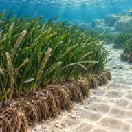
Posidonia meadow
Almost always · Alka
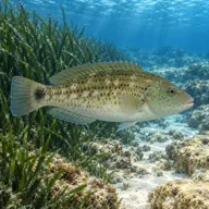
Peacock wrasse
Almost always · Lappun
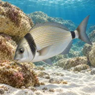
Two banded seabream
Almost always · Sargu
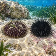
Sea urchins
Almost always · Rizzi
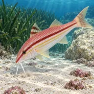
Red mullet
Often · Trilja

Common octopus
Sometimes · Qarnit
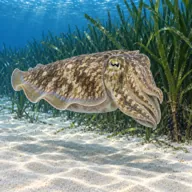
Cuttlefish
Sometimes · Siċċa · Spring
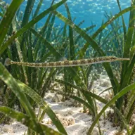
Pipefish in the seagrass
Sometimes · Gremxula tal-baħar

Common stingray on the sand
Lucky day · Bumarin
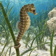
Short snouted seahorse
Lucky day · Żiemel tal-baħar
Getting in and staying safe
Drive out along the Marfa ridge past Mellieha and follow the signs for Armier. There is parking by the beach, plus bars, kiosks and toilets in season, and the entry is straight off the sand, which makes it one of the gentler walks in kit on the island. Out of season the place is close to deserted and many of the facilities are shut. The bay is busy with swimmers and small craft through the summer, so a surface marker is worth carrying even in five metres.
- Small boats, jet skis and swimmers through the summer season
- No shot line or marker on the anchor, so navigation is on you
- Sand and silt stirred up easily in shallow water
- Weed and old fishing line around the chain
- Sunburn and heat on a long surface swim with no shade
A bit of history
Nothing is firmly published about which vessel the anchor came from. Admiralty pattern anchors of this size are usually associated with the British naval presence in Malta, and the northern anchorages along the Marfa ridge and off Comino were used as sheltered holding ground for centuries, so a lost anchor there is unsurprising rather than mysterious. Treat any specific date or ship you are told as folklore until somebody produces a document.
Divers say
Sign in to rate this site and leave a note for the next diver.
- No reviews yet. First one gets bragging rights.
Further reading: Malta Dive Sites: Armier Bay · Visit Malta: Armier Bay · Visit Malta: shore dive sites