Malta
Munxar Cave & Reef
A long finger of rock running out from the Munxar headland with caves cut into its flanks, an arch at around 35 metres and walls dropping into the blue on both sides. Boat only, exposed, and worth timing properly.
Sea conditions
Good right now
Some chop (0.5 m E)
Forecast for the site, updated 01:46 AM
- Waves
- 0.5 m
- from E
- Wind
- n/a
- Swell
- 0.5 m
- 5 s period
- Sea temp
- 28 °C
Next 7 days
Exposed to wind and swell from: N (0°), NE (45°), E (90°), SE (135°), S (180°). This is a properly exposed piece of water sticking out into the open southeast. Westerlies are your friend; anything with east or northeast in it kills the day. Visibility is typically very good, commonly 25 metres and occasionally far more. Watch the current on the reef top, which can be running hard even when the surface looks placid. Best season: May to October. September often gives the best combination of warm water, calm easterly conditions and clear water..
The dive
Munxar is the southern jaw of St Thomas Bay, and the reef is its continuation underwater: a ridge that keeps going east-northeast for the better part of 700 metres before giving up. Munxar Rock, a couple of hundred metres out, sits nine or ten metres under the surface and carries a cardinal buoy, which is where most boats tie in.
The interest is in the sides rather than the top. North and south the ground falls away to 30, 40 and in places 45 metres, and the flanks are riddled with cuts, crevices, craggy pinnacles and cave mouths. The best of the caves is out towards the eastern end, a big-mouthed thing whose ceiling rises almost to the top of the reef, so you get a genuine cathedral effect with light coming in behind you. Further along and deeper there is an arch at roughly 35 metres.
Because the reef stands proud in open water it collects fish. Grouper sit in the holes, octopus occupy the crevices, and amberjack and tuna cruise past on the seaward side often enough that people talk about it.
You can dive the cave and the reef as one long dive or split them over two tanks. Either way this is an advanced site: it is exposed, the current can arrive without warning, and it is a long way from an easy exit.
- A big-mouthed cave whose roof climbs almost to the reef top
- Arch at around 35 metres for those with the gas to reach it
- Walls dropping to 40 metres plus on both sides of the ridge
- Regular amberjack and tuna traffic on the seaward flank
- Rarely crowded, most boats head north instead
Typical plan
Tie in on the buoy over Munxar Rock, drop down the flank to 30 to 35 metres, work east along the wall picking off the cave and, if the plan allows, the arch, then turn and come back shallower along the ridge top at 12 to 18 metres to burn off nitrogen among the cuts and pinnacles. Around 40 to 45 minutes on nitrox 32, deco-free if you are disciplined about the turn. Torch, DSMB and a firm maximum depth agreed before you splash.
What the bottom looks like
- 1Munxar Rock, reef top under the cardinal buoy9 m deep · 8 m out
- 2Craggy pinnacles and cuts along the ridge16 m deep · 70 m out
- 3South flank falling away22 m deep · 110 m out
- 4Large eastern cave with a ceiling reaching near the reef top28 m deep · 150 m out
- 5Arch on the deeper section of the reef35 m deep · 220 m out
- 6Drop into the deeper sand on the seaward side38 m deep · 260 m out
- 7Sand floor at the foot of the reef45 m deep · 360 m out
Hard limestone reef broken by cuts and caves, with coarse sand and rubble collecting at the foot of both flanks.
Who you might meet
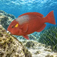
Mediterranean parrotfish
Almost always · Marzpan
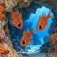
Cardinalfish
Almost always · Re tat-trilji
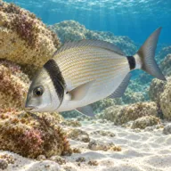
Two-banded bream
Almost always · Sargu
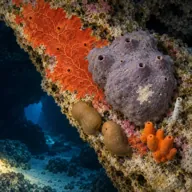
Encrusting sponges
Almost always · Sponża

Dusky grouper
Often · Ċerna
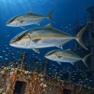
Amberjack
Often · Aċċola · Late summer and autumn

Common octopus
Often · Qarnit

Mediterranean moray
Often · Morina
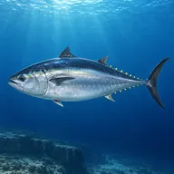
Atlantic bluefin tuna
Sometimes · Tonn · Summer
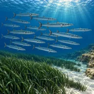
Barracuda
Sometimes · Lizz
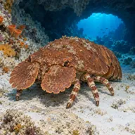
Slipper lobster
Sometimes · Ċikala
Getting in and staying safe
Boat only. Charters run from Marsaskala and from the marinas further round the southeast coast, and the ride out takes roughly half an hour depending on where you start. Boats generally pick up the cardinal buoy over Munxar Rock. There is no shore option worth attempting: the headland is rugged, the swim would be long, and the exit in any sea would be nasty. Park at the boat charter, and use Marsaskala for coffee, food and toilets before and after.
- Occasional strong currents, especially over the shallow top of the reef
- Exposed open-water site with no shelter if conditions deteriorate
- Depths of 40 metres and more on both flanks, easy to overshoot a plan
- Cave and cavern overheads, torch and line awareness needed
- Boat traffic and fishing activity around the buoy
- Discarded fishing line and nets snagged on the reef
- Surge inside the cave mouths on a swelly day
A bit of history
No wreck and no legend attached, just geology. The Munxar ridge is the submerged extension of a limestone spur, undercut and hollowed by wave action over a very long time, which is where the caves and cuts come from. Ashore, the headland is a well known walking route out past the Munxar Window, a natural arch in the cliff edge, and the bay behind it has been a fishing and swimming spot for Marsaskala for generations.
Divers say
Sign in to rate this site and leave a note for the next diver.
- No reviews yet. First one gets bragging rights.
Further reading: Calypso Sub-Aqua Club: Munxar Reef · Divers Guide: Munxar Cave and Reef · Divemed: Munxar Reef and Cave · Malta Dive Sites: Munxar Cave/Reef · Wikipedia: St Thomas' Bay