A 52 m East German built patrol boat sitting upright on sand at 34 m, reachable on a shore dive from Ċirkewwa. Clean, photogenic and probably the most satisfying wreck in Malta for the effort involved.
 Wreck
Sea conditions
Stay dry right now
Sea is up (3.6 m WNW) · Fresh WNW wind (38 km/h) · Gusts to 63 km/h
Done for today. Tomorrow: not looking good. Best it gets is 21 at 16:00: Sea is up (1.4 m WNW)
Forecast for the site, updated 19:45 · Models disagree
Measured at Mġarr, Gozo (2.7 km away, 20:29): 36 km/h from WNW, gusts 41. The next hours lean on it.
- Waves
- 3.6 m
- from WNW, biggest 5.5
- Wind
- 38 km/h
- WNW, gusts 63
- Swell
- 0.4 m
- 7 s period
- Sea temp
- 22 °C
- air 18 °C
Hour by hour
Next 7 days
 0 3.6 m
45 W
 0 3.5 m
43 WNW
39 0.9 m14 W
 95 0.3 m
13 ESE
 100 0.3 m
12 E
84 0.3 m18 NNW
88 0.3 m16 SSW
Sunrise 06:26, sunset 17:06
Waves: Copernicus Med-Waves 4 km + MFWAM 8 km + EWAM 5 km + ECMWF WAM 9 km. Wind: ICON-2I 2 km + ECMWF IFS 9 km + ICON-EU 7 km + UKMO 10 km + ARPEGE 11 km. Read a few km out on the side the site is open to, then blended.
Exposed to wind and swell from: NW (315°), W (270°), N (0°). Entry and exit are the limiting factor rather than the wreck itself. Any northwesterly or westerly of strength puts surge on the stairs and haze in the shallows, and once that happens the site closes. In a northerly through southeasterly it is usually glass. Best season: May to October for the warmest water and best visibility, though it dives well any time the northwest quarter is quiet..
The dive
The P29 has an unfair advantage over most wrecks: you can walk to her. Down the steps at Susie's Pool, out across the shallow plateau, and after about five minutes of swimming the sand falls away and a warship appears below you, sitting bolt upright on her keel with her bow pointed out to sea. She is 52 m long and the top of her mast and superstructure reaches within 12 m of the surface, so she is in view for most of the descent.
Navigation is unusually kind. Two landmarks mark the route out, first a memorial stone lying on the sand, then an old anchor in the seagrass, and in summer a big yellow buoy floats above the wreck so you can surface swim out and drop straight down if you prefer. Either way you arrive at the stern first, closest to shore, and work forward along the deck.
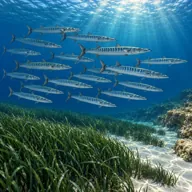
Because she was prepared properly before sinking, the interior is genuinely open. Swim throughs run from midships all the way to the bow, and there is a shorter route through the stern. The engines came out before scuttling, so the machinery spaces are more cavern than engine room. If you would rather stay outside, the deck fittings, the gun mount, the bridge windows and the rails are covered in growth and busy with fish. Bream shoal over the foredeck, groupers sit under the overhangs, and barracuda hang in the blue off the bow in late summer.
- A 52 m warship you can reach without a boat
- Sitting perfectly upright with mast within 12 m of the surface
- Open swim throughs from midships to the bow
- Memorial stone and anchor as a ready made navigation trail
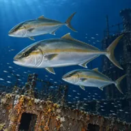
- Barracuda and amberjack hanging off the bow in autumn
Typical plan
Nitrox 32 if you can get it. Surface swim to the buoy or navigate out in midwater, descend the stern at 34 m, work forward along the deck and up over the bridge, then either a short penetration with a torch and a guide or a lap of the outside. Aim for around twenty minutes on the wreck, then ascend to the mast, follow the reef and seagrass back shallow, and use the last ten minutes above 10 m as a long, relaxed safety stop before the stairs.
What the bottom looks like
- 1Susie's Pool plateau5 m deep · 15 m out
- 2Memorial stone to Frank Pembridge on the sand16 m deep · 70 m out
- 3Old anchor on the Posidonia, second navigation landmark24 m deep · 105 m out
- 4Stern of P29, nearest point to shore34 m deep · 145 m out
- 5Bridge and superstructure20 m deep · 165 m out
- 6Mast top, shallowest part of the wreck12 m deep · 180 m out
- 7Foredeck and gun mount26 m deep · 195 m out
- 8Bow, pointing out to sea34 m deep · 208 m out


Pale sand under the hull, with Posidonia meadow and low reef between the wreck and the shore.
Who you might meet
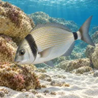
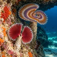
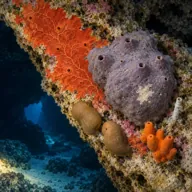
Often
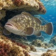

Sometimes
Marked ones can hurt you. What they do and what to do about it is under Getting in and staying safe.
Getting in and staying safe
Shore dive from the Ċirkewwa diver car park, with your certification card displayed on the dashboard. Walk to the Susie's Pool stairs, which drop you into waist deep water in a natural alcove, then either swim out on the surface to the summer buoy or navigate out in midwater past the memorial stone and the anchor. Exit is back up the same stairs, which feel considerably steeper after a 34 m dive. Toilets, cafes and shade are a couple of minutes away at the ferry terminal.
The buoy over the wreck
Yellow marker buoy laid over the wreck
35° 59.430' N 14° 19.540' E
35.99050, 14.32567 · Open in Google Maps
Laid from May to October (Notice to Mariners 48 of 2017).
Positions as charted (WGS84) in Transport Malta Notice to Mariners 42 of 2017, special mark buoys indicating a wreck . Check the latest notice before you rely on them.
- 34 m on the sand, so no stop time is short and narcosis is real
- Penetration carries overhead and silt risk and needs a torch and training
- Sharp edges and corroded steel inside the hull
- Long swim back to shore at the end of a deep dive, so watch your gas
- Busy site with multiple groups on the wreck at once
- Boat traffic above, so surface at the buoy or deploy a marker
- Slippery steps on the way out
- Surge at the entry if there is any northwesterly running
Marine life to respect
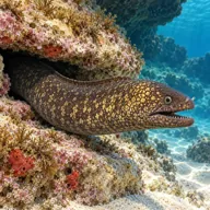
Mediterranean moray · Morina Can hurt you
Bites hard if a hand goes into its hole. Keep hands out of cracks and never feed one.
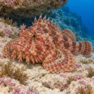
Red scorpionfish · Ċippullazza Can hurt you
Venomous spines, and it sits still on the rock. Look before you kneel or hold on; hot water if stung.
A bit of history
She was built at the Peene Werft yard in Wolgast, East Germany, launched in May 1970 as the Kondor I class minesweeper Boltenhagen with pennant GS09, named after a town on the Baltic coast. Besides minesweeping she patrolled the river border between East and West Germany. After reunification she passed to the German Federal Coast Guard as BG31 and was decommissioned in 1996, the last Kondor I still in their service. Malta bought her in 1997 and renamed her P29, joining two sister ships already serving as P30 and P31, and she spent seven years with the Maritime Squadron of the Armed Forces of Malta chasing smugglers and running border patrols before being paid off in 2004. The Malta Tourism Authority bought her in September 2005 for scuttling. Contaminants were stripped and both engines removed, the site was shifted about 30 m at the last minute to spare the seabed, and bad weather pushed the sinking back three days. She finally went down off Susie's Pool on the afternoon of 14 August 2007.
Divers say
Sign in to rate this site and leave a note for the next diver.
- No reviews yet. First one gets bragging rights.
Further reading: Wikipedia: Maltese patrol boat P29 · Ċirkewwa Marine Park: Patrol Boat P29 · Malta Dive Sites: P29 · Wrecksite.eu entry · Dive Shack Malta: P29 minesweeper