Ras il-Hobz · Gozo
Fessej Rock
A black fang of limestone standing alone off Gozo's south coast, rising 15 metres into the air and dropping 60 metres below it. Boat only, and worth the ride.
Sea conditions
Excellent right now
Flat, sheltered and calm
Forecast for the site, updated 01:45 AM
- Waves
- 0.3 m
- from SE
- Wind
- n/a
- Swell
- 0.2 m
- 5 s period
- Sea temp
- 29 °C
Next 7 days
Exposed to wind and swell from: E (90°), SE (135°), S (180°), SW (225°), W (270°). An isolated offshore rock, so almost every sector except the north is open to it. Guides rate it as best in a north westerly, when the bulk of Gozo takes the sting out of the sea. Anything from the south makes it undiveable and probably unreachable. Best season: June to September, when the south coast is calmest and boat trips run reliably. Visibility is typically 20 m and can reach 30 m or more..
The dive
Fessej Rock is the kind of dive site that sells itself before you even get wet. It is a single, sheer stack sitting roughly a hundred metres off the coast near the mouth of Mgarr ix-Xini, dark with guano above the waterline and plastered with life below it. Boats moor over the shallow western shelf at around 10 to 15 metres, and the standard plan is to circle the rock anticlockwise, dropping deeper as you come round.
The topography is the draw. The rock is riddled with crevices, overhangs and gaps between fallen boulders that you can swim through, and the eastern side falls away in a steep drop towards 50 metres with the base sitting near 60. The shallow side is where the colour is: overhangs full of sponge, small fish jammed into every crack, octopus playing statue. The deep side is where the size is: grouper under the ledges, bream in shoals, and fast movers hanging in the blue where the wall meets open water.
It is exposed out there, and that is the catch. Surge wraps around the stack, current can run, and the whole plan depends on a calm sea and a skipper happy to sit off it. Local guides rate it as a dive best done when the wind is in the north west, which sounds backwards for a south coast site until you remember the shelter comes from the island itself. Shore access is a non starter: the nearest land is Ta' Cenc, and getting there means crossing private ground.
- A free standing stack you can circumnavigate in a single dive
- Swimthroughs between tumbled boulders on the shallow side
- Steep eastern drop towards 50 m with grouper on the ledges
- Genuinely offshore feel, pelagics in the blue
Typical plan
Drop onto the shallow western shelf, work anticlockwise around the rock and let the ground take you down to 30 metres or so on the eastern face. Turn before you are tempted further, then spiral back up the shallow side through the overhangs and swimthroughs, finishing on the top of the stack at 8 to 10 metres for a long safety stop under the boat. Thirty five to forty five minutes, nitrox 32 for the multilevel profile, and an SMB on the belt in case the boat has drifted.
What the bottom looks like
- 1Shallow western shelf where boats moor12 m deep · 15 m out
- 2Gaps and passages between fallen boulders26 m deep · 70 m out
- 3Steep eastern face towards 50 m45 m deep · 120 m out
- 4Sand at the foot of the stack58 m deep · 155 m out
- 5Colourful overhangs on the shallow side20 m deep · 240 m out
- 6Top of the rock for the safety stop8 m deep · 300 m out
Sheer coralline limestone with tumbled boulders at its foot, standing on coarse sand at around 60 metres.
Who you might meet
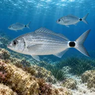
Saddled bream
Almost always · Kaħlija
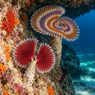
Spiral tube worm
Almost always

Dusky grouper
Often · Ċerna
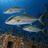
Greater amberjack
Often · Aċċola · Late summer
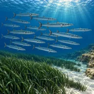
Mediterranean barracuda
Often · Lizz · Summer

Mediterranean moray
Often · Morina

Common octopus
Often · Qarnit

Scorpionfish
Often · Ċippullazza
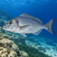
Common dentex
Sometimes · Dentiċi
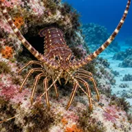
Spiny lobster
Sometimes · Awwista
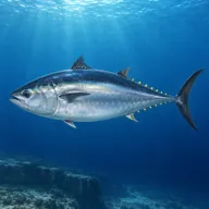
Atlantic bluefin tuna
Lucky day · Tonn · Summer
Getting in and staying safe
Boat only. Most operators run out from Mgarr harbour or from the Gozo dive centres on the south east side, with a trip of roughly half an hour depending on where you start. Boats normally sit over the shallow western shelf; a shot line or a skipper who will follow your bubbles is worth having, because there is nothing to hold on to at the surface. There is no shore alternative: the land behind the rock is the Ta' Cenc cliff line and access across it is private.
- Surge wrapping around the stack, especially in the shallows
- Current that can run unpredictably around an isolated pinnacle
- Depth: the base is near 60 m with nothing between you and it
- Fully exposed offshore position with no shelter if conditions turn
- Boat cover essential, carry an SMB for the ascent
- Swimthroughs and overhangs, watch your cylinder and your buoyancy
A bit of history
No wreck and no legend, just a fine piece of Maltese geology. Fessej Rock is an isolated remnant of Lower Coralline Limestone, the hard basal unit that also forms the Ta' Cenc cliffs looming behind it. The Maltese name Skoll tal-Fessej marks it as a skoll, the local term for an offshore rock or islet, and English speaking divers have called it Black Rock for decades on account of its colour.
Divers say
Sign in to rate this site and leave a note for the next diver.
- No reviews yet. First one gets bragging rights.
Further reading: Calypso Sub Aqua Club, Fessej Rock · Divers Guide, Fessej Rock conditions and data · SSI MyDiveGuide, Fessej Rock · Greatest Dive Sites, Fessej Rock