Comino
Elephant Rock
A natural limestone arch with a thirty-metre tunnel running through the headland behind it, all of it in six metres of water and lit like a stage set.
Sea conditions
Excellent right now
Flat, sheltered and calm
Forecast for the site, updated 02:29 AM
- Waves
- n/a
- Wind
- 4 km/h
- S, gusts 8
- Swell
- n/a
- Sea temp
- n/a
- air 25 °C
Next 7 days
Sunrise 06:47, sunset 19:05
Exposed to wind and swell from: E (90°), NE (45°), SE (135°). Sheltered from the south-west, which is why it works on days when the Lantern Point sites are closed. The flip side is that anything with east in it puts swell straight onto this shore and surge into the tunnel. Currents are generally light and variable. Visibility is typically twenty to forty metres, often around thirty. Best season: May to October, with the tunnel best lit around the middle of the day.
The dive
Elephant Rock earns its name from a lump of coralline limestone that has weathered into something with a convincing trunk and head, arching out of the sea off Comino's eastern shore. It has an eight-metre span and photographs beautifully from a boat, but the real attraction sits behind it.
The Santa Marija Tunnel is a straight passage about thirty metres long that cuts through the headland, with its entrance at around six metres. The depth barely changes from one end to the other, which makes it one of the least intimidating overhead swims anywhere in the islands: you can see daylight at both ends for most of the route. Take a torch anyway, because the walls are where the interest is. Sponges, bryozoans and small corals encrust the sides in colours that simply do not appear in ambient light.
Outside the tunnel the ground is sandy with thin patches of Posidonia, and big boulders piled against the shore create swim-throughs and overhangs. Fish numbers are modest in the tunnel itself, then pick up at the entrances where chromis and bream mill about. Grouper, octopus, moray and the occasional Mediterranean parrotfish work the boulder field, and a slow diver can find plenty on the sand.
It is rated for all levels, which is fair for the site as a whole, but the tunnel is still an overhead environment. Treat it like one, go in a sensible order, and do not enter it if there is swell running: this shore takes weather from the east.
- A thirty-metre tunnel you can swim in six metres of water
- Sponge and bryozoan colour on the tunnel walls once a torch goes on
- The arch itself, one of the better-looking rock features left in the islands
- A dive that works when the south-westerly has closed everything else
Typical plan
Shallow and relaxed. Drop beside the arch, work the boulders at four to six metres, then run the tunnel one buddy pair at a time with torches on, keeping your fins off the floor. Come out the far side, loop the sand and seagrass to a maximum of ten to fifteen metres and return. Air is plenty, an hour is normal, and the only real kit requirement beyond a torch is an SMB for the boat-traffic surface.
What the bottom looks like
- 1Elephant Rock arch, roughly 8 m span2 m deep · 15 m out
- 2Santa Marija Tunnel entrance6 m deep · 40 m out
- 3Tunnel walls encrusted with sponges and bryozoans6 m deep · 60 m out
- 4Boulder pile with swim-throughs and overhangs8 m deep · 100 m out
- 5Sparse Posidonia patches11 m deep · 145 m out
- 6Open sand off the headland16 m deep · 200 m out
Sandy bottom with sparse Posidonia patches, backed by stacked coralline limestone boulders against the headland.
Who you might meet
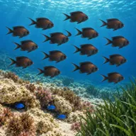
Damselfish
Almost always · Kaħlija
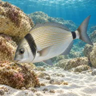
Two-banded seabream
Almost always · Ħaddiema
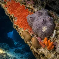
Encrusting sponges
Almost always · Sponża
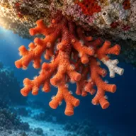
Bryozoans
Almost always
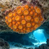
Golden cup coral
Often · Qroll tad-dell

Common octopus
Often · Qarnita
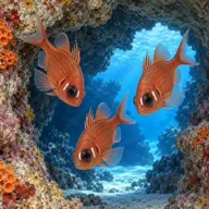
Cardinalfish
Often · Sultan iċ-ċawl
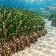
Posidonia meadow
Often · Ħaxix il-baħar

Dusky grouper
Sometimes · Ċerna

Mediterranean moray
Sometimes · Morina
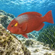
Mediterranean parrotfish
Sometimes · Marzpan
Getting in and staying safe
Boat only, roughly half an hour on a charter from Malta and about twenty minutes from Ċirkewwa. Boats lie off the headland and divers giant-stride in, exiting by ladder. Snorkellers and cave-tour boats use the same water, so expect company. Nothing ashore: Comino's east coast has no landing, no facilities and no road access anywhere on the island. The nearest kiosks and seasonal toilets are at Santa Marija Bay.
- Overhead environment in the tunnel, roughly 30 m with no mid-route exit
- Surge and swell against this shore, uncomfortable inside the passage
- Tour boats, jet skis and snorkellers directly overhead
- Silt and fine sand kicked up in the tunnel
- Sharp rock and urchins on the boulders
- Low light without a torch, easy to miss the wall life and the exits
- Jellyfish in late summer
A bit of history
The arch is an erosional feature cut through upper coralline limestone, the same hard cap rock that produced Malta's other sea arches. The Azure Window at Dwejra in Gozo was the most famous of them until it collapsed during a storm in March 2017, a useful reminder that these spans are temporary on a geological clock. The nearby Santa Marija Caves on Comino's northern coast are part of the same jointed limestone system, with at least ten known chambers and swim-throughs, none deeper than about eight metres.
Divers say
Sign in to rate this site and leave a note for the next diver.
- No reviews yet. First one gets bragging rights.
Further reading: Calypso SAC, Santa Marija Tunnel and Elephant Rock · Divers Guide, Elephant Rock · DiveWise Malta, Santa Marija Caves · Malta Uncovered, Comino caves and Elephant Rock