Gozo
Il-Margun
Two enormous caves cut into a notch in Gozo's north coast cliff, running from near the clifftop down to the sea and carrying on below it, with a boulder seabed falling away to forty metres. Rarely visited and quietly spectacular.
Sea conditions
Excellent right now
Flat, sheltered and calm
Forecast for the site, updated 01:47 AM
- Waves
- 0.4 m
- from ESE
- Wind
- n/a
- Swell
- 0.3 m
- 5 s period
- Sea temp
- 28 °C
Next 7 days
Exposed to wind and swell from: N (0°), NE (45°), NW (315°), W (270°). A summer, settled sea site. Anything northerly builds on this coast within an hour and the skippers will call it early. Flat southerly days are the ones to aim for. Best season: June to October, with the best visibility usually in September and October..
The dive
Round the corner from Forna Point the cliff steps back into a sharp indent, and the first thing you see is the caves. They are not modest: two openings that run from close to the top of the cliff right down through the waterline and keep going, so above water you are looking up into darkness and below water you are looking into it as well. The larger one is Għar tal-Margun, the cormorant cave, and the birds it is named for still use it.
Underneath, the seabed is boulders, all sizes, piled and tilted against each other down a slope that reaches forty metres before it eases. The gaps between them are the dive. Moray poke out of holes you were not expecting, octopus rearrange the pebble doorsteps of their dens, dentex and bream come and look at you because so few divers pass through here that curiosity has not been trained out of them. The rock itself carries good encrusting growth in the shade under the overhangs.
The catch is getting here. It is boat only, on a coast that closes at the first hint of a northerly, and it is far enough along that most centres will only run it as part of a longer day. Currents come and go around the point next door. Ask about it when the forecast is flat and southerly, and if the skipper says yes, take the offer.
- Two caves running from near the clifftop down past the waterline
- Boulder field descending to 40 metres with life in every gap
- A cliff notch that sees a handful of divers a season at most
- Better than average odds on moray, dentex and curious grouper
- North coast water clarity at its best in autumn
Typical plan
Drop under the cave mouths, descend the boulder slope to a planned 35 or 40 metres and spend ten to twelve minutes working the gullies down there. Come up in stages along the slope, give yourself fifteen minutes in the twenties among the boulders, and finish under the cave entrances in shallow water with a stop at 6 metres. Forty-five minutes on nitrox 32, a torch each for the cave mouths, and a delayed SMB up before you leave the bottom.
What the bottom looks like
- 1Għar tal-Margun, the cormorant cave5 m deep · 15 m out
- 2Second cave in the cliff indent9 m deep · 32 m out
- 3Slope steepens below the cave mouths21 m deep · 65 m out
- 4Boulder field of every size32 m deep · 130 m out
- 5Deepest rock before the ground eases40 m deep · 205 m out
- 6Shallow rock under the cave entrances11 m deep · 380 m out
Tumbled boulders of every size on bare limestone, with pockets of coarse sand and shell gravel between them.
Who you might meet
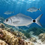
Saddled bream
Almost always · Kaħlija
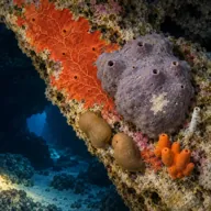
Encrusting sponges
Almost always · Sponża

Mediterranean moray
Often · Morina

Common octopus
Often · Qarnit
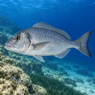
Dentex
Often · Dentiċi

Cardinalfish
Often · Re di trilji · In the caves

Dusky grouper
Sometimes · Ċerna

Scorpionfish
Sometimes · Ċippullazza

Greater amberjack
Sometimes · Aċċola · Late summer
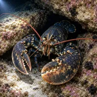
European lobster
Lucky day · Awwista
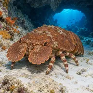
Slipper lobster
Lucky day · Ċikala
Getting in and staying safe
Boat only, most easily from Marsalforn, which is the shortest run to this part of the north coast. Charters also come from Mġarr and Xlendi when the weather suits, usually combining Il-Margun with Forna Point or Ħekka Point on the same trip. There is no shore, no ladder, no shelter and nothing at all at the site, so everything you need travels with you. Expect an anchored or live-boat drop and plan a delayed SMB for the pick-up.
- Depth: the boulder slope runs to 40 m and keeps going in places
- Occasional and unpredictable current, strongest near the headland
- Overhead in both caves, with darkness and no through route
- Boat-only access with an unbroken cliff and no shore bail-out
- Surge inside the cave mouths in any north swell
- Loose rock and unstable boulders on the slope
- Narcosis at the deeper end of the boulder field on air
A bit of history
The Maltese margun refers to the cormorant, the seabird that roosts and nests in cliff caves like these; the name simply records who lived here first. The cliffs on this stretch are Lower Coralline limestone and the caves are sea-cut hollows opened along vertical joints, the same process that produced the arches and windows elsewhere on the island. Il-Margun sits between Ħekka Point to the west and Ras il-Forna to the east, and guides often treat the whole indent and headland as one area, which is why the cave shows up in write-ups for both sites. There are no wrecks and no recorded incidents here, just a very old piece of coastline that almost nobody visits.
Divers say
Sign in to rate this site and leave a note for the next diver.
- No reviews yet. First one gets bragging rights.
Further reading: Divers Guide: Il-Margun · Malta Sub Aqua Club: Forna Point and Għar tal-Margun · Visit Malta: Il-Margun · Malta Dives: Il-Margun