Malta
Għar Ħasan
A boat dive beneath the tall southern cliffs near Birżebbuġa: a shallow rock plateau whose edges fall away steeply into the blue, with the famous land cave riddling the limestone overhead.
Sea conditions
Good right now
Some chop (0.5 m ESE)
Forecast for the site, updated 01:48 AM
- Waves
- 0.5 m
- from ESE
- Wind
- n/a
- Swell
- 0.5 m
- 5 s period
- Sea temp
- 29 °C
Next 7 days
Exposed to wind and swell from: SE (135°), S (180°), SW (225°), W (270°), NW (315°). Calypso Sub-Aqua Club flag exposure to northwesterly and southerly winds, with slight surface current setting in after northerlies. In practice the site is dived on calm summer mornings and abandoned as soon as there is anything in the sea from the south. Visibility is typically 10 to 40 m with an average nearer 25 m. Best season: June to September, on settled mornings before the afternoon sea breeze fills in..
The dive
The south coast of Malta is mostly vertical, which is why so little of it gets dived from shore. Għar Ħasan is one of the exceptions worth the boat ride. The cliffs here stand over a hundred metres above the water and the rock is Lower Coralline Limestone, old, hard and full of holes, which is exactly the kind of geology that produces good diving.
Underwater the pattern is a shelf that sits shallow, around 3 m at its top, running out from the cape before its flanks drop off steeply. Follow the edge and you are quickly at 15 m, then 25, then 40 if you want it. The wall and the boulder slope below are pitted with recesses, ledges and small cavities, and those holes hold fish. Away from the wall the ground opens into sand and weed where rays and octopus work.
On a clear day the visibility here is outstanding by Maltese standards, frequently 25 m or more and sometimes far better, because there is nothing but deep open water to the south. What you are paying for, in effort and boat fuel, is that emptiness: big blue, big rock, and no crowd at all.
- Some of the clearest water around Malta, with 25 m visibility the norm
- Steep coralline wall and boulder slope running past 40 m
- Towering cliff scenery on the boat ride in
- Almost never crowded
Typical plan
Drop onto the shallow plateau, cross to the edge and follow the wall down to your planned maximum, commonly 25 to 30 m for a recreational profile. Work back along the wall at progressively shallower depths, finishing on the plateau at 5 to 8 m where the light and the wrasse are. Thirty-five to forty-five minutes on EAN32 is a sensible plan; on air, watch the clock closely below 30 m. DSMB on every dive here, since the boat may have to stand well off the cliff.
What the bottom looks like
- 1Shallow plateau west of the cape3 m deep · 15 m out
- 2Plateau edge steepening into wall8 m deep · 70 m out
- 3Cavities and recesses in the coralline rock15 m deep · 120 m out
- 4Fallen boulder slope below the wall24 m deep · 175 m out
- 5Deep drop into the blue34 m deep · 230 m out
- 6Sand and weed at the foot of the slope40 m deep · 295 m out
Hard Lower Coralline Limestone, ledged and pocketed, with fallen boulders on the slope and patches of sand and weed at the bottom of the drop.
Who you might meet
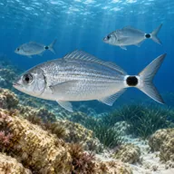
Saddled bream
Almost always · Kaħlija sewda
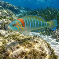
Wrasses
Almost always · Tirda tal-passa

Sea cucumbers
Almost always · Bużżu tal-baħar

Starfish
Almost always · Stilla tal-baħar

Common octopus
Often · Qarnita
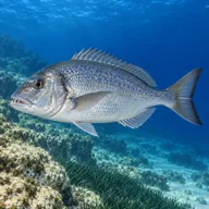
Common dentex
Often · Dentiċi

Dusky grouper
Sometimes · Ċerna

Stingray
Sometimes · Boll

Mediterranean moray
Sometimes · Morina
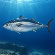
Atlantic bluefin tuna
Lucky day · Tonn · Summer
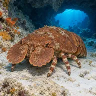
Slipper lobster
Lucky day · Ċkala
Getting in and staying safe
Boat only. There is no safe shore entry anywhere along this cliff-bound coast, and the land cave above is gated shut in any case. Boats generally come round from Marsaxlokk, Birżebbuġa or Wied iż-Żurrieq. No facilities of any kind at the site: bring everything, including shade.
- Cliff-bound coast with no shore exit and no easy pick-up if you drift
- Depth: the wall runs well past 40 m and it is easy to sink lower than planned
- Surface current after northerly winds, sometimes light but persistent
- Exposed swell from the south building quickly with no warning
- Rock fall from the cliffs above onto the boat area
- No mobile signal or immediate assistance on this stretch
- Sea urchins and sharp coralline rock on the shallow plateau
A bit of history
The cave in the cliff above takes its name from a Maltese legend about Hasan, variously told as a Muslim ship's captain or an enslaved man, who is said to have used the cave as a refuge around 1122 and who, in most versions, ends up going over the cliff along with a Maltese woman named Katrina. The cave itself is around 390 m long, formed by karst dissolution of the Lower Coralline Limestone in the late Pliocene or early Pleistocene, with fossil shells and urchins in the passage walls and red terra rossa soil on the floor. Rock falls in 2004 led to its official closure, and a gate was fitted across the approach path in 2022, so the land cave is no longer open to visitors.
Divers say
Sign in to rate this site and leave a note for the next diver.
- No reviews yet. First one gets bragging rights.
Further reading: Calypso Sub-Aqua Club: Ghar Hasan · DiveBoat Malta: Ghar Hasan · Wikipedia: Għar Ħasan · Lonely Planet: Għar Ħasan Cave