A named stretch of collapsed limestone shoreline on Gozo's north coast at Nadur, between San Blas and Daħlet Qorrot, under Ta' Sopu Tower. Nobody publishes a dive report for it, so anything you do here is prospecting rather than following a route.
 Other
Divers rarely, if ever, come here.
We found no record of anyone diving this site. It is charted so the picture of what lies under the water is complete, not because it is a place to go: there is no set route, no local briefing to lean on, and nothing on this page has been proven in the water.
Sea conditions
Reading the sea…
Exposed to wind and swell from: NW (315°), N (0°), NE (45°), E (90°). The coast faces roughly north northeast, so anything from northwest round through east puts sea onto the rocks and rules it out. Guides for the next inlet along at Daħlet Qorrot say the same thing in reverse, that it wants wind from the west or the south. Aim for a settled southerly or southwesterly with a flat swell forecast, and remember that on this shore a moderate northerly does not just spoil visibility, it takes away your exit. Best season: Late May to early October, on days with a southerly or southwesterly airflow and no northerly swell left over. Water is warmest and clearest from August into October..
The dive
Start with the name, because it trips people up. Mistra Rocks is on Gozo, not on Malta. The Mistra most divers picture is the bay behind Xemxija on the main island, and that is a different site entirely. This one is a length of broken coast in the parish of Nadur, running from the red sand of San Blas east to the mouth of Wied ir-Riħan at Daħlet Qorrot, with the squat bulk of Ta' Sopu Tower keeping watch from the cliff above.
What gives the place its character is the wreckage of the cliff itself. The land here is a jumble of fallen blocks, some of them the size of a small house, stacked on each other with dark gaps and hollows running back between them. That is the classic Gozitan north coast recipe: hard Upper Coralline limestone sitting on soft blue clay, the clay creeping seaward, the cap breaking up and sliding down in slabs. There is no reason the process stops at the waterline, and the underwater ground below a coast like this is normally the same talus carrying on down into deeper water.
Here is the honest part. No dive centre sells this site, the site indexes carry it with no depth, no rating and no reviews, and we could not find a single published dive report. The neighbour at Daħlet Qorrot is a documented, friendly beginner dive over seagrass and sand in about ten metres, and that is the closest thing to evidence about what the water does around here. Everything we say below about the underwater shape is reasoned from the coastline and from how the rest of this shore behaves, and it is labelled as inference rather than fact.
So treat Mistra Rocks as an exploratory outing. Go on a flat day in settled southerly weather, go with a boat or with somebody who knows this corner of Gozo, keep it shallow and short, and write down what you find. The next diver will thank you for it.
- A named piece of Gozo coast that almost nobody has logged a dive on
- House sized fallen blocks under Ta' Sopu Tower, with the talus likely carrying on underwater
- Quiet fishing cove at Daħlet Qorrot to start and finish from
- Seagrass and sand shallows that hold gurnard, lizardfish and the odd stingray
- Only on in settled southerly weather, which makes getting it a small achievement
Typical plan
There is no established route, so plan conservatively. From the pebbles or the quay at Daħlet Qorrot, drop in and follow the bottom out of the inlet over the neptune grass and sand at eight to ten metres, keeping the rock on your right. Round the western arm and pick up the boulder ground, then work west along it, letting it take you to about eighteen or twenty metres and no deeper. Turn on thirds or at twenty five minutes, whichever comes first, and come back shallower over the same ground so the seagrass shallows give you a soft finish. A single twelve litre of air is plenty for these depths. Fly a delayed marker if you surface anywhere off the rocks, because the fishing boats come through, and if you are being dropped by boat agree the pick up point and a fallback before you get wet. Better still, treat the first visit as a snorkel and a look, then come back with tanks once you know what is down there.
What the bottom looks like
- 1Neptune grass and sand patches across the mouth of Daħlet Qorrot9 m deep · 150 m out · under the boat
- 2Step down where the western arm of the inlet ends (inferred)14 m deep · 320 m out · 170 m from the boat
- 3Fallen limestone blocks below the Ta' Sopu cliffs (inferred)18 m deep · 500 m out · 350 m from the boat
- 4Gaps and talus hollows between stacked blocks (inferred)20 m deep · 650 m out · 500 m from the boat
- 5Sand and rubble at the foot of the slope (inferred)25 m deep · 900 m out · 750 m from the boat


Most likely coralline limestone slabs and tumbled boulders close under the cliff, breaking up into rubble and then sand with patchy Posidonia where the ground flattens, which is what the documented seabed at neighbouring Daħlet Qorrot looks like.
Who you might meet
Almost always


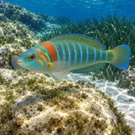

Often
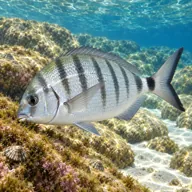




Sometimes
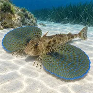
Marked ones can hurt you. What they do and what to do about it is under Getting in and staying safe.
Getting in and staying safe
Only for serious professionals who know exactly what they are doing. With no record of anyone diving here there is no one to ask and no set route, so treat every line below as the start of your own planning, not a briefing. Plan it as an expedition, not a dive.
Nothing here is laid on for divers. The practical way in is Daħlet Qorrot, at the eastern end of the stretch, where a narrow lane drops from Nadur to a small fishing cove with a quay, boathouses cut into the rock and a pebble beach. You can park near the water, kit up on the flat and walk in off the pebbles or step off the quay. From there the rocks run away to the west, and the marker sits several hundred metres along, so an honest shore plan means either a decent surface swim or a dive that only touches the eastern end. San Blas at the other end has a road that is notoriously steep and badly surfaced and no realistic kit carry to speak of, so we would not start there. The sane option is a boat drop from Daħlet Qorrot or Marsalforn with a pick up on the surface. There are no toilets, no ladders, no dive centre presence and no phone reception you should count on. Walk the coast on a calm day and look at the water before you commit to anything.
- Almost no published information, so any dive here is genuinely exploratory
- North facing coast where swell breaks straight onto rock and makes exit ugly
- Surge and washing machine water among the fallen blocks when there is any sea running
- Long surface swim from the only drivable entry at Daħlet Qorrot
- Small fishing boats working in and out of Daħlet Qorrot, so fly a marker buoy
- Snagged line, netting and lost pots around a coast that is fished from the shore
- Loose ground and slippery rock if you scramble along the shoreline in kit
- No dive centre cover, remote from roads and slow for any assistance to reach you
- Mauve stinger jellyfish possible in late summer and autumn
Marine life to respect

Common stingray · Boll Can hurt you
Whips a barbed tail if stepped on or cornered. Stay off the sand and give it room.

Mediterranean moray · Morina Can hurt you
Bites hard if a hand goes into its hole. Keep hands out of cracks and never feed one.
A bit of history
The human story here is above the water. Ta' Sopu Tower, also called Isopu Tower or San Blas Tower, was raised in 1667 under Grand Master Nicolas Cotoner and paid for by the Università of Gozo, which also covered its garrison while the Order supplied the guns. It was left unmanned for a while, then rearmed in 1792 with four six pounder iron guns, and in June 1798 it did something no other small Maltese watchtower did: it opened fire on the approaching French fleet. Din l-Art Ħelwa and the Nadur local council restored it between 2003 and 2006 and reopened it to visitors in August 2006. The ground around it carries the marks of a century or more of farming, with rubble walls and old water channels, and a few pockets were quarried, though most of the coast has simply been left alone. The rock formations themselves are the work of the blue clay underneath giving way and letting the coralline limestone cap break and slide toward the sea.
Divers say
Sign in to rate this site and leave a note for the next diver.
- No reviews yet. First one gets bragging rights.
Further reading: Wikipedia, Mistra Rocks: location, extent, geology and position · Wikipedia, Sopu Tower: 1667 build, 1798 action, restoration and coordinates · MaltaDives site entry, the indexed position and the not dived status · Atlantis Gozo, Daħlet Qorrot dive site, the nearest documented dive · Wikipedia, San Blas Bay: western end of the stretch and its access road · divinginfo.mt Gozo dive site listing, confirms the name and its alias